


Overview for the week and 5-day outlook to Wednesday 05 December 2018
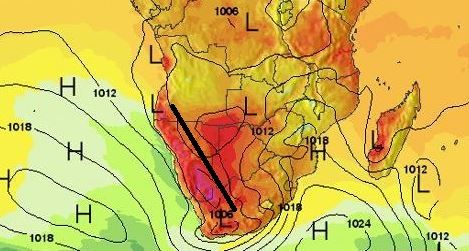
Visual 1: Surface pressure and temperatures on Friday afternoon, 30 November.
Source: www.meteoblue.com/en/weather/map/pressure/africa
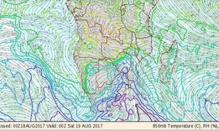
Visual 2: Cloud development in the convergence zone indicated in the first visual as a thick, black line.
Source: www.meteoblue.com/en/weather/forecast/week/ondwi_namibia_11258458
What Happened
This was again one of those weeks where a winter stance prevailed west, south and east of the sub-continent with a limited effect up to about the Orange River, and heavy summer conditions north-east of the weak mid-level trough that was in situ for most of the week.
The two visuals are both from Meteoblue, a weather analysis and forecast site with more than a dozen monitoring points for Namibia. Both visuals are based on satellite telemetry and both are for more or less the same time, 14:00 on Friday afternoon.
This week started with low pressure conditions covering most of the sub-continent. The South Atlantic high pressure cell stayed mostly offshore with only a weak intrusion along the west coast while the previous week’s continental high remained stationery just south of Madagascar. As the week progressed, the South Atlantic high lost some of its strength, reading a mild 1020 mB by Friday but the high south of Madagascar retained its core strength at 1024 mB.
The result was visible in the mid-level trough which stayed put across Namibia and became visible every afternoon as the clouds built up. Its position is indicated by the thick black line in the first visual but this is only an approximate position since the trough typically wanders over a week. The usual shift will be to the east but in our case it often happens, especially when the South Atlantic high is weaker, that the trough shifts to the west. This is what happened this week, bringing sporadic rainfall to large areas in the north-west, the central interior and further east to the Botswana border.

The second visual shows the actual cloud formation along the convergence zone which usually coincides with the trough but at a slightly higher altitude. It is the line where the Atlantic and tropical systems meet, and nine out of ten times, that zone runs across Namibia, exactly as shown.
The mid-level trough is a signature feature of Namibia’s weather. It is only in mid-winter that it is absent and for the rest of the year, it is the moisture conveyor from Angola into Namibia. Therefore, it is important to observe its position and relative strength.
What’s Coming
A cut-off low sits across the southern Cape at the bottom end of the trough running from Angola through Namibia into South Africa. This low pressure system works like a suction pump, boosting the trough, making it stronger and advecting more moisture into Namibian airspace.
Again the question is, how far west will the trough shift, or how quickly will it depart to the east?
Friday’s conditions continue through the weekend with lower pressures over the interior, a prominent airflow from the north, and sweltering heat over northern Botswana and the Caprivi.
The South Atlantic high stays weaker, its outer rim remaining offshore. This has the potential for cloud development across the entire country east of the escarpment but the bias will be over the central high ground, the north-eastern quadrant and along the Botswana border.
There is very little change in conditions for next week Monday to Wednesday. It can rain almost anywhere where conditions are favourable, but the rainfall will be light and sporadic. It is almost impossible to predict.


