The Week’s Weather 16 December 2016
Oceanic and atmospheric conditions in the tropical Pacific are gradually shifting to a La Nina stance. While the official designation is still ENSO neutral, sea surface temperatures over a vast area of the eastern and central Pacific are between 0.5°C and 1°C warmer than the 40-year mean. This area stretches roughly from 90° W longitude to the international dateline, a distance of almost 10,000 km. North to South, the cooler water now lies between 8°N and 8°S latitude, around 1700 km in extent.
From these figures it is obvious that the eastern and central Pacific is cooler than normal and that this area covers some 17 million square kilometres, indeed a vast piece of ocean, which is the reason why the El Nino Southern Oscillation (ENSO) has such a huge impact on global weather.
It is only the Maritime Continent that is warmer than normal by about half a degree. This is important to us since the ocean south of Indonesia is fed from the Maritime Continent trough the Indonesian archipelago. When sea surface temperatures in the Maritime Continent start cooling, it feeds through to the Indian Ocean. When the water south of Indonesia cools, and the water along the African east coast gets warmer, the so-called Indian Ocean Dipole turns positive. This coupled climate mechanism is now neutral coming from a fairly long period of negative.
If sea surface temperatures in the Pacific continue to recede, the eastern part of the Indian Ocean will subsequently also become cooler, giving us a positive Indian Ocean Dipole. This is what we need during the main rainfall season from December to April. Although overall conditions are not there yet, the bigger picture has certainly become positive since June this year.
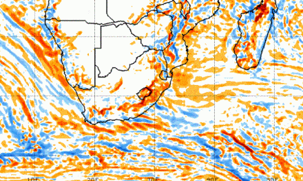
This week the southern African sub-continent continued to be dominated by low pressure conditions over the interior, and the two customary high pressure systems in their customary positions west and east of the continent.
The South Atlantic high pressure cell remained weak and displaced northward, the core more or less in line with Walvis Bay. The southern Indian high pressure cell was slightly stronger, the core lying some 2000 km south-east of Madagascar. The surface circulation over the sub-continent was anti-cyclonic with only western and southern Namibia, and the western half of South Africa, impacted by the outer rim of the South Atlantic high. South of the Mariental latitude, heat wave condition in the upper levels of the atmosphere continued, leading to very hot days over most of the southern half of southern Africa.
Towards the end of the week, the protruding (leading) rim of the South Atlantic high has migrated around Cape Agulhas and became separated from the mother cell. In between a low pressure area formed with a strong north to south airflow separating the two highs. This offshore development amplified the north to south flow over Namibia with enhanced penetration of moisture between 11,000 and 18,000 feet. Penetration over Namibia went deep into the south, even to the eastern half of the Karas region but the cloud base remained elevated due to the surface impact of the offshore high. By week’s end though, the high has receded and much cloud started developing over almost the entire country excepting the southern Namib. By Friday convection was enhanced, and for the first time this season, CB cover exceeded 5/8.
What’s Coming
The continental low pressure system covers the DRC, Zambia, Angola, Namibia, Botswana and western South Africa. It provides a broad conveyor of moisture from north to south.
Precipitation is forecast for the north-eastern quadrant throughout the weekend and up to Tuesday night. The outer rim of the South Atlantic high continues to impact surface conditions with a clear convergence zone running across Namibia from Ruacana in the north-west to the Karasburg district in the south-east. North and east of the convergence line, rainfall is possible with intensities increasing the further north one goes.
By Tuesday next week, the Kalahari and the western parts of both the Hardap and the Karas regions will be blisteringly hot.
The wind at the coast will be fresh south-westerly for the next four days.