


Weather overview and short-term outlook to Wednesday 19 May 2021
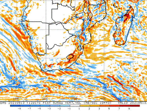
Visual: Vertical velocity at 925 mB.
Source: Climate Prediction Centre, National Oceanic and Atmospheric Administration of the US Government, www.cpc.ncep.noaa.gov/products/international/cpci/data/12/fcsts_safrica.shtml
Recent Developments
With little or zero indications of atmospheric humidity, i.e. no clouds visible, this week’s visual provides a very interesting view of air movement over southern Africa.
This type of synoptic map, while slightly confusing at first, is actually fairly easy to understand. The key lies in the legend below the map. Blue indicates negative acceleration, that means rising air (ascending) and orange indicates positive acceleration, i.e. sinking air (descending).
The next rule of thumb is that when air rises, temperatures drop gradually and windy conditions set in. The reverse is of course true, when air sinks, temperatures go up and the air becomes stable or less windy.
In essence, what the map is showing us is that early winter conditions have set in over most of the southern African interior, hence no activity, with the only areas of instability located at or near the escarpment.
First, this is an indication how important topography is for the sub-continent’s weather. The interior, as opposed to the coastal plains, is anything between 1100 metres and 1600 metres above sea level, excluding mountains. In practise, this means that the topographic features of southern Africa must always be brought into consideration when trying to form a meaningful picture of local weather.
For Namibia, the map is very straightforward. Where the orange blotches are, the air will tend to move from east to west and to sink indicating precursor conditions to proper Oosweer. This is offset, however, by rising columns of air where the Oosweer conditions will dissipate, the temperatures will be cooler and windy conditions will occur intermittently during any 24-hour cycle.
What we see is that there are conditions positive for Oosweer in the vicinity of the escarpment, but as one moves closer to the coastline, this gets replaced by blue blotches, meaning if Oosweer or Oosweer-like conditions occur in the desert, they will not reach the ocean. This phenomenon is often observed during the summer winter transition when it may be 34° C at Arandis while only 50 kilometres further west, at Swakopmund, it may be only 21° or 22° Celsius.
The map itself is valid for 18:00 on Thursday 13 May. This is the time when the sun is low and solar energy is receding fast. What is shows is that on Thursday afternoon, relatively cool but windy conditions persisted over most of the coastline with only two areas of rising temperature. The first is in the north, more or less following the Ugab river valley and the other is in the south over the escarpment north of Ai-Ais.
It also shows that the propensity for airflow above (east of) the escarpment was favouring conditions for sinking air while below the escarpment (west of) on the coastal plain, the bias was for rising air.
On the Radar
There is not much weather change on the horizon. For the entire country (interior), conditions will be calm and sunny over the weekend with a mild to fresh south-westerly wind blowing along the coast.
By Sunday afternoon, conditions will start changing in the south-west (Oranjemund and Lüderitz) with colder conditions setting in over the Sperrgebiet, and spreading to the rest of the Karas region during Monday and Tuesday.
We are still far from cold fronts actually making landfall so there is no fear of frost in the south but by Tuesday next week, the Karas and Hardap regions may see nighttime temperatures go as low as 5° Celsius.


