06 December 2013
![]() What happened?
What happened?
The gradual, but persistent, build-up of favourable rain-bearing patterns continues with scant interruption as the calendar rainfall season advances.
For some weeks now, the consistent presence of tropical moist air: the airmass linked to the broad range of the Inter-Tropical Convergence Zone (ITCZ), has become more and more evident as the summer advances.
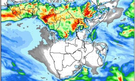
This active weather belt has provided rains, rains of considerable intensity (that means falls of good measure with each thunderstorm cloud) across the sub-continent from the Angolan escarpment eastward. Positive results are already appearing with rapidly increasing river-flows being noted at Ruacana.
The potential of a flood-plume leading to inshore warm water presence (sea-surface temperatures in excess of 25oC) only bodes well where the arena for tropical low pressure cells, associated with the ITCZ, is concerned.
During this past week, the promise has come closer to fruition with some productive levels already recorded on, at least, an isolated basis variously from just about the northwestern escarpment inland to the Botswana border across the northern third: from around Opuwo longtitude to south of Tsumkwe.
The overall situation across the northern half remains positive. Showers have even spread to the coast: Walvis and Gobabeb for instance.
The severe rainfall over Rehoboth on Sunday was an effect of the convergence between moist air from the north and cooler air from the south. This typically happens along the convergency line which transsects Namibia roughly from Ruacana to Mata Mata.
Occasional showers spread also to the south as the upper level vortex formed advecting a band of moist air into its circulation, providing energy which helped trigger its departure: A trite unusual for the time of year, but with some support from the equally valuable and active anticyclonic cores proceeding along their more southerly tracks between some 38 and 45oS. Their added input supports the moist inflows from the east: typical and positive.
What’s coming?
Once more, the prospect of a heat-inspired low pressure belt across southern Namibia dominates the sub-continent surface. Upper air flows remain favourable to advect some moist air. The remains of a drier level seem to persist, but the moisture both beneath and a northwesterly flow above will help the mixing and absorption of this layer.
The prospect for scattered thundershowers stays for this period with an intermittent ability to extend both to the west and further south: somewhat ahead of calendar expectations.
Widespread rain is expected across the northern half of the country for Saturday, Sunday and Monday. Conditions clear from Tuesday onwards with the rest of next week generally expected to be drier.