


Weather overview and short-term outlook to Wednesday 12 January 2022
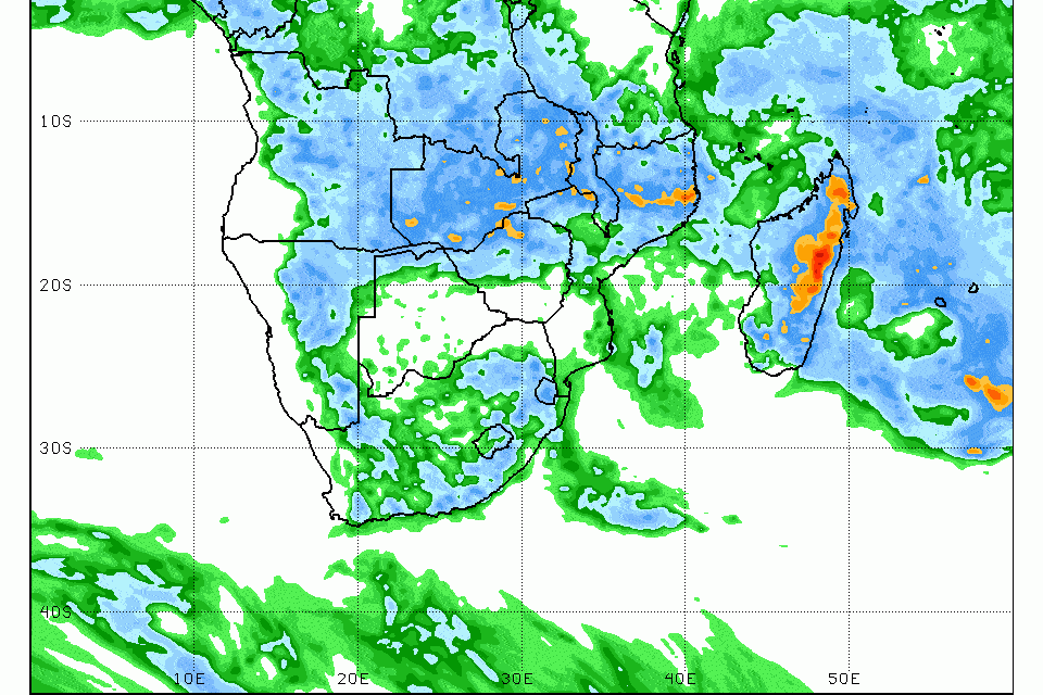
Visual: Effective rainfall forecast for southern Africa for the week 04 to 11 January 2022.
Source: Climate Prediction Centre in the National Oceanic and Atmospheric Administration of the US Government. www.cpc.ncep.noaa.gov/products/international/cpci/data/18/gfs_precip_week1_safrica.html
Recent Developments
For the October to December season we have witnessed a paucity of precipitation much below normal for this period, even in the Kavango, Bwabwata and Zambezi regions.
Although this went against earlier forecasts, the actual reason was not difficult to identify. The South Atlantic High Pressure cell maintained its winter position deep into summer and the distances between the cores of successive cells were generally less than 3000 km.
The result was that only two rainfall windows presented in the whole three months, and falls were generally restricted to the western half of the country, measuring less than 20 mm. The one noticeable incident was that at least on one occasion, the moisture reached the Karas region leading to some spectacular weather events at Keetmanshoop.
However, both these incursions were associated with very strong so-called cut-off low systems that developed about 600 km offshore ahead of the next approaching high, with a marked extension northwards over the continent, deep into the Namibia interior.
This period was also marked by unseasonally strong windy conditions which occurred in cycles of about four days – four days blowing, four days quiet. From this cycle, it is obvious that the main driver was again the South Atlantic high pressure cell, providing the “push” from the ocean, and the solar-induced lower pressure over central Botswana, “sucking” from the interior.
But these generally poor conditions for precipitation started changing during December, first witnessed by the excessive and prolonged rains over the eastern half of the South African interior. This is still continuing as can be seen by the floods in the Orange River this week, which is a combination of saturated ground, and more excessive rains in the Vaalharts area which falls in the Orange River catchment area.
The substantial rains over Botswana and South Africa during December had to have a source and that was the mid-level trough (around 18,000 feet aloft) stuck over the central zone of the sub-continent. This trough is the main rainbearing transport for southern Africa’s summer rain and it meanders from Zimbabwe in the east to southern Angola in the west, as the South Atlantic high comes and goes in cycles.
The only problem for us was the South Atlantic high was so dominant and its core displaced so far north, that the mid-level trough remained over Zambia and Zimbabwe, never getting the opportunity to shift west, even if only for two or three days.
The overall result was that we had a disappointing season before Christmas and that only in the last ten days of December did conditions change over the north-eastern quadrant.
On the Radar
This week visual has been chosen specifically to show that finally, the break has appeared for the current summer rainfall season. The indicated expected totals for the current week and the weekend are not impressive (this is more what we would have expected in December) but the important point is that the mid-level trough has shifted west and now sits over southern Angola and Namibia where it is supposed to be during summer.
A second observation from the visual is inferred. Going by NOAA’s forecast, it is clear that their predictive models assume a southern boundary for the so-called Inter-Tropical Convergence Zone, right on the Namibian Angolan border. This is also a good sign as it was always John Olszewski’s contention that when the ITCZ sits on the Angolan border by Christmas, a good summer rainfall season follows.


