


Weekly overview and short-term outlook to Wednesday 17 April 2019
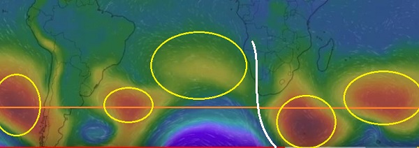
Visual: Synoptic map of surface pressures at midweek, 10 April.
Source: www.windy.com/-Show-add-more-layers/overlays?pressure,-17.225,49.570,3
Recent Developments
The visual shows surface conditions late on Wednesday afternoon, as such providing a good interpretative framework to understand developments both in the first and the second half of the week.
The image has been enhanced with a few practical pointers. The first is the horizontal orange line which indicates the position of the 40°S latitude. This is a significant location benchmark. When the bulk of the South Atlantic high’s 1024 mB core is above (north) of this line, its impact on Namibian weather is more severe. For the better part of this season, it was almost 800 kilometres north of the orange line often on the same latitude as Walvis Bay. This was a very negative signal resulting in the drought.
The second noteworthy feature is the position of the high pressure cell cores marked in yellow circles. Note that the primary southern Indian high is displaced to the south while the primary South Atlantic high and the secondary South Pacific high (either side of South America), straddles the line more or less half half. The secondary southern Indian high is also situated across the line but it is slightly displace to the north. It is only the secondary South Atlantic high (close to the continent) that is visibly displaced far north but it is also very weak.
In comparison, the primary southern Indian high measured 1032 mB earlier in the week while the secondary South Atlantic high only reached 1016 mB. It is also noteworthy that except for the one weak cell, all the major cells are located around 40°S indicating that the pressure bias for the southern hemisphere as a whole has shifted.
The last prominent feature on the visual is the white curve running from southern Angola through Namibia and South Africa to a point in the ocean far south of Cape Agulhas. That line is the most important feature around which the entire week’s weather developed.
The white line shows the position of two major trough which eventually linked up but not at the same elevation. The upper half of the line, from the Orange River further north, is the position of the signature trough (low pressure band) running from Angola into Namibia. This trough sat in the mid-levels between 12,000 and 22,000 feet. It remained active for the duration of the week but without any significant cloud formations other than in the north-east in the Kavango and the east along the Botswana border.
The bottom half of the white line is also a trough but this one started as a protrusion that extended from the lower pressure area south of the continent in a northern direction. The main difference is that this southern trough developed at the alto levels at altitudes way above 30,000 feet. This is too far south and to high to have a direct impact on Namibian weather but it does act like a massive vacuum cleaner, increasing the activity of the northern section of the trough, albeit the latter was substantially lower.
Troughs are by definition low pressure areas implying an unstable atmosphere. It is exactly this instability in the upper atmosphere that has been lacking during this season. These two troughs, although not completely connected, mark a major shift in local conditions compared to the season up until the middle of March.
Another element to observe is the distance between the high south of Madagascar and the South Atlantic high.
By Friday the weak South Atlantic (secondary) high close to the continent has decayed completely while the primary South Atlantic high sat halfway between Africa and South America with its core displaced to the south. Between the two highs (South Atlantic and southern Indian) was a two to three day lacuna, amplified by the two interlinked troughs, working like a massive suction pump, advecting moist air from Angola into the Namibian interior and further south into South Africa.
These two to three day windows are all Namibia needs to receive another bout of good rains before winter.
On the Radar
The approaching South Atlantic high is still offshore for the duration of the weekend but the Karas region will start feeling its bite as colder air moves in at surface level. The central interior will follow more or less the same pattern as this week with noticeably cooler nighttime temperatures and warm to hot days. The northern third of Namibia will continue to experience hot afternoons due to the predominantly northerly airflow.
The mid-level trough is still there (witnessed by the steady north-easterly to north-westerly airflow over the interior (above the escarpment) but it is very weak, so not much in terms of rainfall other than highly isolated showers which may develop into thunder showers given the instability in the alto levels.
For Monday, Tuesday and Wednesday, the current trough is expected to wander to the east with its main activity in central Botswana and northern South Africa. It is however, replaced quickly by another trough which is expected to wander westwards as the South Atlantic high migrates around Cape Agulhas.
This outlook opens up all sorts of possibilities for Namibian rainfall. With an unstable upper atmosphere, a strong north to south airflow, and the South Atlantic far south, there is still a lot of potential to bring us a late-season, wet surprise.


