


Weather Overview and short-term outlook to Wednesday 28 July 2021
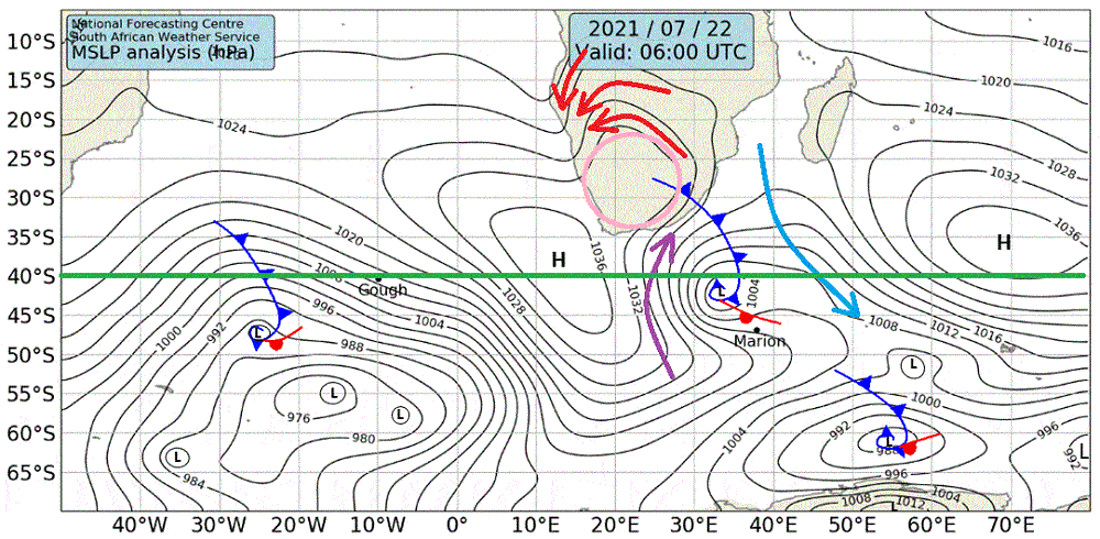
Visual: Synoptic Map of southern Africa for Thursday 22 July at 06:00
Source: South African Weather Service. www.weathersa.co.za/images/data/specialised/ma_sy.gif
Recent Developments
One of John Olszewski’s favourite anecdotes every year was to joke that the winter in Namibia was scheduled for 07 July between 07:00 and 08:00 in the morning but was eventually cancelled due to a lack of interest. This has certainly proven true once again over the past two weeks.
While it is obvious that South Africa experienced a major cold intrusion last week and this week, the local impact was much reduced and limited to single-day events on both occasions.
In short, what we have had winterwise so far, is very regular. It is not a particularly strong or weak winter, it is just a fairly normal winter, albeit delayed by a week or two. The stories about a black-frost winter after the good rain season are just that: – stories, or more precisely, old wives’ tales.
This week’s event can be deduced from the visual which was chosen deliberately to show conditions one day before the major cold intrusion.
There are a few pointers to take from this map.
First, the airflow ahead of the cold front is from north to south, i.e. as indicated by the pastel blue arrow. This means that local conditions are usually pleasant before the front arrives. Note also that on Thursday, the front itself was nearing the continent’s east coast so what blasted us on Friday morning was the frontal system itself, or in learned parlance, the diabatic part of it.
Second, the airflow behind the front is from south to north as indicated by the purple arrow. This airflow follows the so-called isobars (the black contours) so when the South Atlantic high pressure cell forms a prominent core overland (indicated by the pink circle) then the airflow tends to follow the curvature of the isobars around the core. It was quite funny to see the Weather Service saying the cold air came from the Arctic (north pole).
Third, this rotational circulation is the reason why our winter cold always comes from the south on the first day, then veers east on the second day, and north-east on day three, at which point it has basically lost its cold effect. The three red arrows more or less indicate local surface wind direction in the south-east, the central parts and the north-western quadrant.
Now remember, this was a day before the cold spell. Fast forward to Friday morning and the synoptic map still looks very much the same except that the front has departed the land and there is a small but intense patch of cold air (1042mB) in the southern Cape interior.
What this shows us is that by tomorrow (Saturday) the cold will come from the east but it will not be as cold as Friday morning and by Sunday conditions will revert to pleasant again.
On the Radar
After two cold spells with ample frost in the southern, eastern and central regions, the question is whether this was the last of the winter. The answer is: Perhaps.
There is another frontal system on its way and should be here by Tuesday night but the expectation is for the front to collapse as it makes landfall. It will certainly have an impact on Oranjemund, the Orange River Valley and the Karas Region but it is doubtful if it will bring another bout of frost.
What needs out attention is a synoptic aspect that has been evident for the past month. Notice in this week’s visual how the high pressure cores either straddle or hug the 40°S parallel (the green line). This is far south for winter especially given the strong cores.
If this synoptic pattern continues, i.e. if the cores remain so far south during summer, Namibia is in for another good rain season in 2022.


