


Ex Chalane expected to hit northern parts, warns Meteorological Services
By Clifton Movirongo.
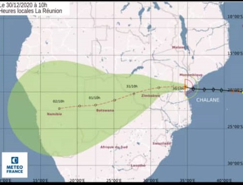
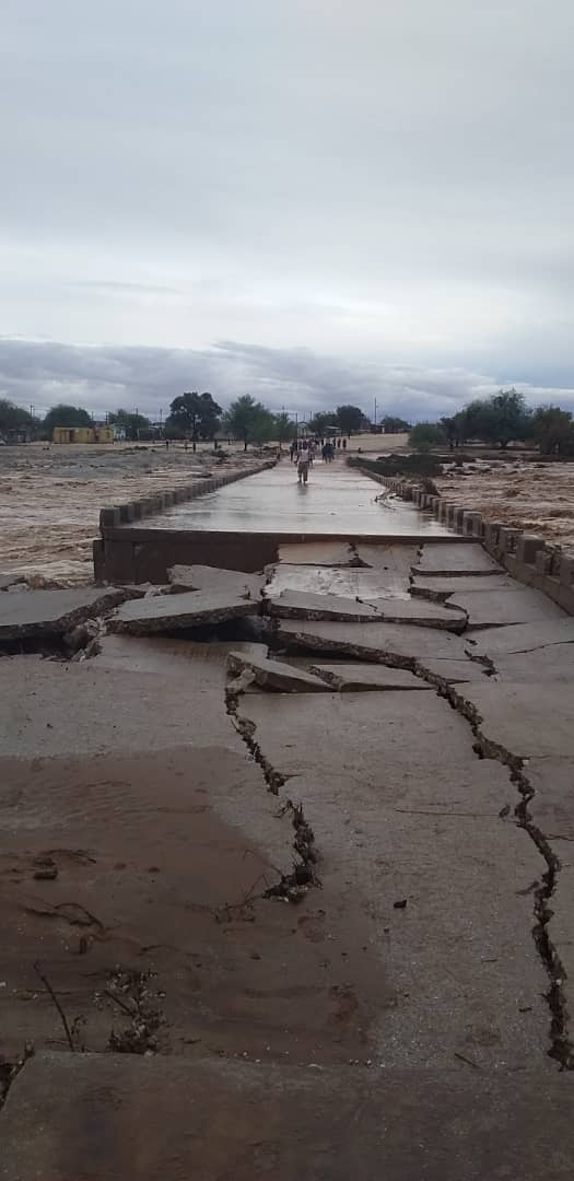
Following extensive damage to several road sections in the southern parts of the country, the tropical depression Ex Chalane cyclone will be making its way to the northern regions where heavy rainfall is expected in the next couple of weeks, according to Namibia Meteorological Services Weather forecaster, Odilo Kgobetsi, who issued a warning this week.
“Heavy storms will start building or set in from Friday night over the far northern regions. We shall continue monitoring and report as the weather situation proceed,” revealed the weather forecaster.
Kgobetsi explained that heavy falls following severe weather conditions were reported on 31 December 2020, in the northeastern and central parts of country and the storms spread to the southern parts on 1 and 2 January .
Given multiple reports about damaged and closed roads in the areas of Keetmanshoop, Grünau, Aroab, Noordoewer, Karasburg and Warmbad, Kgobetsi indicated that the tropical depression has abated although it continues to track in a general northerly direction.
He said places reported more than 100 mm in 24 hours, adding that areas in the South reported significant thunderstorms, – Swartrand 65 mm; Namibrand Nature Reserve 92 mm; Farm Jena near Hochanas 71 mm; Klein Vaalgras 120 mm and Warmbad 95 mm.
Motorists have are being urged to be prudently watchful, discreet and be vigilant during their journeys in the southern parts of the country, while the Roads Authority maintenance team is busy inspecting and assessing the conditions of the roads.
According to statistics made available to the Economist by Namwater and the Ministry of Agriculture, Water and Land Reform, dams in the southern parts of the country received significant inflow due to heavy rains received over most parts of the Orange and Fish Rivers catchments.
“The Orange River flow significantly increased due to the recent heavy rainfall in the southern parts of Namibia and the Northern Cape in South Africa. The flood waters from the Fish River reached the confluence with the Lower Orange River at Sendelingsdrift and passed the 6 meter mark yesterday. The flood waters have receded and river level today 8 January 2021 is at 1.6m at Sendelingsdrift,” Ministry of Agriculture, Director of Hydrological Services, Paulina Mufeti, told the Economist.
However regarding the North, she said no flow has been recorded in the Cuvelai basin yet, although isolated pools of water have been observed in the ‘Cuvelai Iishana’, which is due to localized rainfall in the area.
Additionally, Kgobetsi specified that the southern regions remains at risk as the soil moisture percentage is still very high.
“We rely on the Namibia Meteorological Services rainfall network, where we gathered rainfall figures and also from farmers and individuals. The Meteorological Services will also be issuing advisories or weather warnings when the situation warrants an alert,” he concluded.


