


Weather overview and short term outlook to Wednesday 21 October 2020
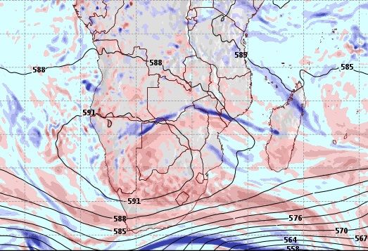
Visual: Height above sea level of the 500mB surface as at 00:00 on Friday 16 October.
Source: GrADS/COLA, George Mason University. www.wxmaps.org/fcst.php
Recent Developments
The very hot days of the past week is a phenomenon known as adiabatic compression. The physics is similar to what we know as Oosweer but the difference is that a so-called heatwave is not a wave at all, like Oosweer, but it is a very tall, static column of air that tends to rise in the morning, and then sink very slowly once the son is past its zenith.
The visual is a snip from the well-known series of weather variables captured every day and then used as the basis for a 7-day forward outlook. The short intervals in data collection (every 24 hours) means that these models are generally robust and the outlook as reliable as can be expected. The visual is the first frame in the series thus it captures real conditions as opposed to predicted conditions.
Over Namibia, Botswana and South Africa’s northern provinces, a large area is enclosed by a black line with the value 591 in the line. This is a reading in decametres (dam) so 591 simply means 5910 metres above sea level or more or less 6 kilometres above the surface. This is also the natural home of the so-called 500mB surface.
As one goes higher into the air, both the temperature and the barometric pressure drop at a steady, fairly predictable rate for a given set of conditions. Pilots are very familiar with this concept and what it means for flying, so they have elaborate formulas to calculate temperature and pressure at specific elevations all based on the observed readings on ground level, in our case done by the weather station in Walvis Bay. This is more than an academic exercise. The pilots lives’ depend on this for one simple reason – the altimeter in the cockpit which one sets to a specific reading before every flight, must be accurate hence the reason for always resetting it before a flight. That it the way they know how high they are above the ground in other words, how much space is between the aeroplane and the runway level.
591 is a high dam reading. It shows that the 500mB is almost at its highest elevation. In practice it means the atmosphere is ‘thick’ with high pressure control in the mid-levels although surface conditions may lean to a low pressure bias. Put simply, when the atmosphere is thick, there is more of it to press down than what would normally be the case.
For Namibia, 585 is a more frequent reading in summer while only occasionally does it read 588. So, when you see a cell (a bubble of air) over Namibia with a 591 reading, you know the atmosphere is really thick and it will be blisteringly hot. This is what a heatwave is.
On the Radar
The heatwave relaxes somewhat over the weekend but the 500mB still sits at a high 588 dam. This should lead to more very hot days on Saturday and on Sunday.
It is only by Monday that this mid-level high pressure cell starts retracting to the Atlantic Ocean. Monday night should be a little cooler.
By Tuesday, the 500mB surface settles at an elevation of 5850 metres, making some space for the signature mid-level trough from Angola across Namibia into South Africa, to form. This will bring cloudy conditions to the interior.
At the same time, a strong cyclonic system moves in over the southern Namib, very similar to two weeks ago. In the north is will be quiet and very hot while in the south-western quadrant it will be much cooler and very windy.
It is possible that by Tuesday night and during next Wednesday, we may again see some rain in the northern areas as well as in the vicinity of the Orange River Valley.


