Weather 16 October 2015
![]() What Happened
What Happened
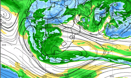
The delicate balance between the South Atlantic high pressure cell and its southern Indian counterpart was vividly demonstrated this week. Both measured 1024 mB at the core, both sat some distance away from the continent, and both covered areas of more or less the same size.
It was in fact a very conventional synoptic picture. The only anomaly is that the South Atlantic high was displaced marginally northward, its core lying offshore of Lüderitz while the southern Indian high was spot on at the 32oS latitude. South of the continent, a succession of cold fronts followed their customary trajectory, pushed along by the South Atlantic high, with little or no impact on local weather.
By Wednesday local conditions started changing witnessed by the cold nights in the Hardap Region. This spilled over to the north with chilly early morning conditions felt as far north as Outjo and Grootfontein. To understand the interplay of the two oceanic highs and its effect on local weather, a bird’s eye view is required.
The South Atlantic high is a very strong, very large system. At its core it is stable, dense and cold and rotates very slowly. But this core sometimes has a diametre of 5000 (five thousand) km and its outer rim, the 1016 mB isobar can cover the entire South Atlantic. As it approaches the continent, its leading edge advects air in the lower level from south to north, in other words, it is the mechanism that brings cold spells. It is known as ridging and it is always an approaching system. The southern Indian high is often just as strong at its core but since the Indian Ocean is generally warmer than the Atlantic Ocean, it tends to be weaker, and situated further south where the water is colder. On its northern rim, it enters the continent across Mozambique and Tanzania, advecting air from east to west traversing the subcontinent in a very large arch, across Malawi, Zambia, the Congo and Angola. This airflow follows a large curve, eventually entering Namibian and Botswana airspace from the north. As it crosses the continent, it heats up, becomes lighter and leads to lower pressure over the interior. This causes the very regular troughs over Namibia. It is always a departing system.
The outer rims of these two highs usually meet somewhere over Namibia along an imaginary line called the convergence line. It is along this line that all the weather activity happens, and it has a major impact on local rainfall as it migrates from west to east. Since the air brought in by the South Atlantic high is colder and denser, it exerts its influence on the surface and in the lower level, typically up to 15,000 feet. When it is dominant, like this week, this ceiling climbs to around 20,000 feet. It is not conducive for rainfall since moisture at this level, at this time of the year, is less than 10%
The recurving outer rim of the southern Indian high, is warmer and lighter. Flowing from the north, it tends to slip over the colder, denser air, usually between 15,000 and 20,000 feet. It is at this mid level that regular troughs has formed for the past month, and it always brought in a broad band of cloud cover from the Kunene to the Kalahari. At the mid level, moisture is in the order of 70% and above, but the extremely dry conditions in the lower level, is what prevents rain. It was again, the story of this week.
What’s Coming
As the South Atlantic high migrates to the east, nighttime temperatures in the Karas Region return to normal. The anti-cyclonic circulation over the sub-continent centres more or less on the Zambezi and the Sashi in Botswana.
The southern regions and the interior up to Okahandja will revert to mild conditions at night and hot days. Over the north-eastern quadrant, daytime temperature will be very hot, reaching the upper thirties every day. A prominent trough forms from Ruacana across the country to Mata Mata in the Kalahari. By Sunday evening this trough spreads towards the coastal plain in the northern Namib, advecting moisture across a very broad tract covering the entire Angolan border and moving towards the south-east along the convergence line. By Monday, it spreads to cover most of the western half of Namibia excluding the southern Namib. It remains however absent from the northern section of the Botswana border. Weak conditions for rainfall are indicated for Monday, Tuesday and Wednesday over the northern half and the interior down to the Orange River.