


Weather overview and short-term outlook to Wednesday 17 June 2020
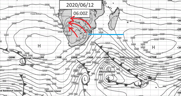
Visual: Synoptic chart for southern Africa, early Friday morning 12 June.
Source: South African Weather Service, www.weathersa.co.za/images/data/specialised/ma_sy.gif .
Recent Developments.
The general weather stance has rapidly shifted to a conventional winter pattern as shown by Friday’s synoptic map of surface conditions.
The South Atlantic High pressure cell is in its customary position, slightly displace to the north, with a core reading of 1032 mB. The Southern Indian high, similarly, shows a barometric pressure of 1032 mB in its core which is situated slightly further south than the South Atlantic high’s core. This is normal due to the warmer water in the Indian Ocean.
The two core readings are also normal for the first part of winter. It is only in July, after the solstice, that the readings will go even higher, to 1036 mB, which corresponds to the coldest part of the Namibian winter.
The feature to note is the distance between the two 1024 mB isobars of the South Atlantic high and the Southern Indian high. As can be seen in the visual (blue line) this is the better part of 2000 km which is somewhat on the long side but not extraordinarily so.
It is this distance that opens a window for the leading rim of the South Atlantic high to make landfall and penetrate deep into the southern African interior (red arrows) since there is very little from the (warmer) north that opposes its northward intrusion. The result this week was our first blast of polar air flowing from south to north immediately behind the cold front which by Friday, has already departed the continent and was situated a few hundred kilometres offshore KwaZulu-Natal.
A further result from the relatively large window between the two highs was the northward extension of the system that produced the Western Cape’s winter rainfall. It is the exception for these systems to reach into Namibian territory but it does happen from time to time when regional conditions permit.
This week it brought rain, wind and ice cold weather to the south up to Lüderitz at the coast and as far north as Keetmanshoop in the interior.
But typical from a passing cold front, the extreme cold will pass in just a day or two as the continental high departs the mainland. This high is not a distinct feature in its own right but is the transitory phase of the same high pressure cell as the South Atlantic high morphs into the southern Indian high.
On the Radar.
The cold conditions linger on for another day during the weekend, reaching as far north as Bushmanland but even Rundu will feel the chill. By Sunday the high has departed and the overall weather picture settles back into a more typical winter pattern.
The next few days will again be mild during the day and cold by night, without any frost expectations except for Friday night and then only on the higher ground in the east, and perhaps at isolated spots in the Hochland.
As of Sunday Oosweer will be prevalent on the coastal plain but it is doubtful that it will reach the shoreline in the central and northern Namib. In the southern Namib windy conditions will prevail.
By Wednesday the next approaching cold front shows up on the synoptic map but it will be another three days, around Saturday next weekend, before it shows up in Namibia. How far north it will reach, will at that stage depend on the strength and proximity of the Southern Indian high.


