


Weather overview and short-term outlook to Wednesday 10 June 2020
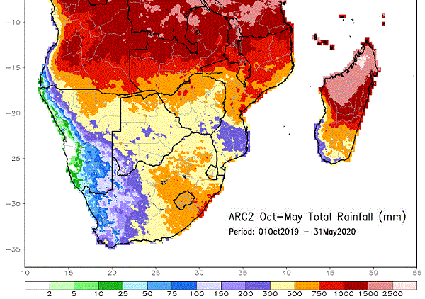
Visual: Cumulative rainfall for southern Africa for the 8 months of the main summer season.
Source: Climate Prediction Centre in the National Oceanic and Atmospheric Administration of the US Government. www.cpc.ncep.noaa.gov/products/international/africa_arc/africa_arc_Oct-May_sa_obs.gif .
Recent Developments
The see-saw season continues unabated. Overall conditions do not yet reflect a winter stance but the proximity and strength of the South Atlantic high pressure cell are growing so it is only a matter of time before mid-winter arrives.
This week’s visual shows a computer compilation of inferred rainfall for the past season based on satellite telemetry, corroborated in some places by actual measured falls. What is most revealing is that Namibia, at best, had only an average season but that parts of northern Namibia, southern and central Angola, parts of Zambia and parts of the southern DRC, had an above-average season.
This map highlights the fact that the 11-day window in February when the central dams filled up, was nothing short of a miracle. For the rest, it was a very regular season. It also shows that the high water levels in the northern rivers can be traced back to the good rains at their headwaters in central Angola.
Over the past month, the southern boundary of the Inter-Tropical Convergence Zone (ITCZ) has steadily retracted northward. During the rain season its dominant position coincided more or less with the red shading in the visual, i.e. where the 750 mm isohyet runs. Note also that this line stretches basically from the Atlantic to the Indian Ocean and that it is well-demarcated, except for a small pocket of sporadic higher falls in central Mozambique. Currently, however, the ITCZ sits far to the north at the border between Angola and the DRC.
The local weather of the past two weeks was mild with only a brief cold intrusion early in the previous week. From then onwards, the regular daily pattern repeated itself for the entire country. The only blips that stood out from the monotony occurred when there were windy conditions in the southern Namib, or mild Oosweer in the central Namib.
The exception was the intrusion of moisture this week but this was a typical result of the see-saw weather. The moisture came from Western Zambia, crossing the Caprivi and entering the Namibian interior through the Kavango East and Otjozondjupa regions. The moisture content was however relatively low, in the order of 40% at surface level. In the absence of convection, it needs a little lift for clouds to form and that lift came from the South Atlantic high pressure cell as it covered the south-western quadrant of Namibia.
The clouds were part of a convergence zone that formed where the warmer, moister air from the north encountered the colder, denser air from the Atlantic. The warmer layer slides over the colder layer which is spread almost like a huge blanket across the land. This pushes up the warmer air and condensation takes place. The result is a broad layer of shallow clouds, deceptive in its appearance, but basically devoid of any rainy potential.
On the Radar
The subdued conditions continue over the weekend with little or no Oosweer. The airflow remains predominantly from the east so there is a chance of Oosweer in the central Namib, and perhaps the northern section up to Terrace but the wind is so slight that it is doubtful that this air movement will actually reach the coastline.
In the south, the picture looks somewhat different. A major cold front (the first serious front for the winter) approaches the Cape during Sunday and makes landfall on Monday. By Tuesday this system pushes far north, reaching Lüderitz on the coast and pushing inland up to the Fish River Valley and into the southern areas of the Karasburg district. The whole southern Namib and most of the Karas Region can expect cold, windy and wet conditions on Tuesday and these may linger into Wednesday as the system shifts east.
As is usual, the colder weather moves to Botswana a day later, thus penetrating Namibia from the east on Thursday or Friday.


