


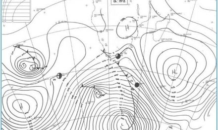
The Week’s Weather up to Friday 10 March Five-day outlook to Wednesday 15 March

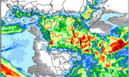
Precipitation forecast from Thursday 09 March to Friday 17 March
Source: wxmaps.org, GrADS/COLA
There is a raging debate on the culmination of the rain season. After two wet spells, most Namibian reservoirs are repleted to a greater or a lesser degree but there are still many districts in the west and the south where rainfall has disappointed and grazing is still as poor as during the drought.
In the Pacific Ocean, the weak La Nina has never matured but it also has not transitioned to an El Nino either. Going by the so-called El Nino Index (ENI) compiled by the National Oceanic and Atmospheric Administration of the US government, conditions are ENSO neutral. In the western Pacific sea surface temperatures are close to normal while in the eastern Pacific, sea surface temperatures are higher by as much as 2°C. But, and this is a big but, the warmer water is only in the upper 50 metres. Below that the water is cooler, in general by about half a degree but over very large areas by one to one and a half degrees Celcius. Also, it is noteworthy that the two cooler patches at the surface have merged during the past week, creating an area of slightly cooler water on or near the equator that strecthes for almost 9000 (nine thousand) kilometres. This is a big chunk of ocean with cooler conditions going down as deep as 500 metres.
The reasonable assumption for Namibian weather watchers is that the La Nina, although weak and fragmented in places, is far from over. For the next six month ENSO neutral conditions are expected and the possibility of a new El Nino only features after the end of the summer in the northern hemisphere.
Namibia’s weather this week was controlled again by the South Atlantic high pressure cell. To understand its impact, it can be imagined as a huge flat bubble of air that rests on the surface. It enters Namibian terrirtory through the southern Namib from where it gradually spreads to the north as it migrates to the east. During the day with solar radiation the colder air heats up, rises and the barometric pressure drops but as soon as the sun is past its zenith, the system receives less energy and the process reverses. Typically during summer, the high has an impact up to about 12,000 feet.
Meanwhile, from the north-east comes warmer, lighter air carrying the vapour it has collected from the Indian Ocean. Where it meets the high on the surface it tends to slip over it and covers Namibia from north-east to south-west. This often very broad zone is calle the convergence zone and it is very difficult to predict with any amount of certainty how the interaction between the higher pressure on the ground and the lower pressure aloft, will impact the formation, or the elevation of cloud.
This interaction was vividly dispalyed this week. Cloud formation happened every day across the entire country except the southern coastal plain but in most instances the cloud base was too high, i.e. above 12,000 feet, for effective convection.
However, over the Kaokoveld, a strong cyclonic circulation was present, similar to conditions two weeks ago, which created a clearly defined convection zone strectching from the Kunene mouth through Owamboland where it linked up with the Inter-Tropical Convergence Zone. The result was high and persistent rainfall but only up to about 200 km south of the Namibia Angola border.
The rest of the country, despite the visible presence of good cloud, could produce at most isolated medium showers of about 20 mm.
Cyclone Enawo which ravaged Madagascar for the week migrated from north to south only moving overland to some extent. This cyclone carried an extremely high vapour load which it transported in the upper levels into the Inter-Tropical Convergence Zone. 500 mB charts show the interaction between Enawo and the ITCZ clearly as the moisture was transported from around Madagascar across southern Africa up to southern Angola and northern Namibia.
What’s Coming
The question about the end of the rain season is a difficult one. Certainly, March is statistically the third most important rain month after January and February but this year January was a miss except for the northern-most regions.
There is still much life in the bigger markers that determine local rainfall conditions. The Indian Ocean cyclone season is active; the ITCZ is active and still strong although during the past week it shifted about 600 km north; sea surface temperatures around Madagascar are slightly elevated; the core of the South Atlantic high is displaced slightly southward, and the frontal systems that usually preceed it, are active indicating the ready potential for mid-level troughs to develop over the sub-continent.
During the weekend, rainfall is only forecast for the thin strip adjacent to the Namibia Angola border but it runs along the entire northern border up to Mpalila and beyond.
Rainfall expectations for the rest of the country are bleak.
As from Monday, there is a low pressure system originating in Angola and entering Namibia across the Kunene River. In the meantime, the South Atlantic high has moved around Cape Agulhas and pushes up the Mozambican Channel. The eastern half of southern Africa therefore is under high pressure control next week and all rainbearing systems are displaced north of 18°S latitude.
It is only from around Wednesday next week that the low pressure system in the west grows strong enough to develop into a mid-level trough, that may or may not succeed in crossing Namibia. Conditions are very fluid and the robustness of the forecast model is dimished more than 48 hours out.


