


Weather overview and short-term outlook to Wednesday 29 April 2020
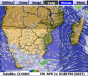
Visual: Animated satellite image of cloud formation and stream lines for central and southern Africa as on Friday 24 April around noon.
Source: Space Science and Engineering Center, University of Wisconson-Madison.
www.ssec.wisc.edu/data/paw/eueu_soaf_clds_anim_none.html
Recent Developments
This week’s visual provides a good framework to understand the weather elements that brought so much relief during the week to a very large area of Namibia’s South.
The South was indeed blessed from around Wednesday, albeit so late in the season. As can be seen in the animation, a relatively strong cut-off low developed offshore between Lüderitz and Oranjemund. This cut-off low was an extension of a low pressure system that developed over the Atlantic Ocean west of Cape Town but which shed much of its strength when it moved onto land. It was however strong enough on its northern rim, first to create fairly unstable conditions close to the surface, and then extend to the alto levels as high as 35,000 feet.
On its western rim, the cut-off low was driven by the South Atlantic high pressure cell, enhancing the south to north airflow out at sea. On the eastern side, the motion came mostly from the anti-cyclonic circulation with its pivot over South Africa. This in turn is an effect of the passing high pressure cell as it morphs from the South Atlantic high into the southern Indian high.
In the meantime, closer to the surface, from ground level to about 15,000 feet aloft, moisture continued to penetrate Namibian airspace from the north and north-east. This dispells the notion that the moisture source from where the South’s rain came, is the high pressure front of the Cape.
The interaction between high and low pressure systems over southern Namibia drove the airflow but the source of moisture was still tropical.
A cut-off low works like a huge vacuum pump. At the surface it is just slightly less dense than the surrounding atmosphere but the higher up it goes, the more powerful it gets. It advects exponential volumes of air from the surface to the alto levels and this air has to come from somewhere.
When it interacts with the mid-level trough that is almost a standard feature of Namibia’s summer weather, it boosts the airflow in the trough, sucking it from north to south where it enters the core of the vortex and from where it is again distributed into the atmosphere at elevations above 35,000 feet.
This activity can be seen clearly in the visual. The core of the cut-off low is the gyrating circle over the ocean between Lüderitz and Oranjemund while the north to south airflow is indicated by the streamlines flowing from southern Angola and Western Zambia into the Namibian interior.
The result was widespread rains over the southern Namib, the Swartrand, the Bethanien district up to the Orange River, and in the west in the Keetmanshoop and Karasburg districts. The reported falls measured roughly between 20mm and 40mm with many smaller, and not so small, rivers in flood.
On the Radar
The current low pressure system over the South quickly departs to the east where it dissipates by Sunday but another frontal extension is on its way, also with the potential to form a strong cut-off low.
This should reach the South during Monday, possibly extending its stay into Tuesday, but by Wednesday it has also departed and dissipated. It has, however, the potential to bring another bout of widespread rain to the South.
For the rest of the country, no rain is indicated but clouds will continue to form every day over the interior, for the same reason as the mechanism described above. This means that there is always a small possibility of isolated, brief showers where local conditions are positive.
The limiting factor is that the clouds are restricted to the middle levels between 15,000 and 25,000 feet. It is only where good convection develops that some rain may be expected. This will be announced by lightning and thunder.


