Understanding Weather – not predicting – 26 October 2012
What happened?
Proof that the weather world has a long sleeve and surprises abound was brought home to us once more. An upper vortex formed just south of the Cape, which in itself is not exceptional for October, but this has happened regularly, almost on a weekly basis. Each time the vortex develops, it has several unique features, unlike the expected pattern.
A closed vortex held sway, dominating the upper air charts from 700 to above the 400hPa levels. From the 850hPa level down to the surface, there was not even a bend, the undercutting ridge developed its core, moving rapidly around and beyond the vortex core. All this saw remarkable weather occur.
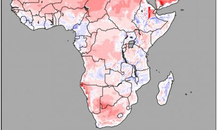
The 0C isotherm was far inland at the 700hPa level. The charts showed this upper vortex with a western extension to the south: advecting air from 50oS at least.
What did this mean for us? The southerly flow at the 850hPa level had penetrated deep into the country. Warmth was limited (by October standards) to our far northerly areas. The distant vortex core created a trough above our southern regions so emphasizing this flow pattern. The typical pattern was cold nights, reminiscent of winter, with warm to hot afternoons.
Because the surface pattern advanced so quickly, airflows advected deep into the eastern sub-continent, the colder unstable air aloft built, just as quickly, numerous thunderstorms (another undercutting style) over those eastern parts: such momentum also ensures moist air advance deep into the mid-continent bringing convective cloud over the Okavango catchment and extending southward.
After all, this could now seem closer to October’s norm. Daytime warmth spread quickly down south, but the persistent upper air anticyclone to our west blocked any further westward advection other than the redeveloping surface “heat-low” trough: from the Owambo regions to mid-Omaheke.
Rainy events were recorded here, but confined to this northeastern area.
To recap, the weather excesses adjacent to our south and east and the overflow both north and westward are “also normal” by our experience. The ability to block is equally on record. The recurrence of these ranges is also not unknown; the matter is that this set of replays survives for months rather than weeks. The longer term implications involve several conflicting influences regarding our historically drier weather patterns.
What’s coming?
Apart from these northeastern regions, the dry, hot prospect for much of the country persists.
A trough departs during Friday, weakly recurring by Monday. Two forecasts maintain northerly orientated flows to persist with only brief diversion throughout.
The NOAA projection offers an increased possibility of some showers, but matching the wind-flow and the heat low from southern Angola, above the Okavango catchment and the border regions, restricts this zone. Other projections are less promising: very typical for late October, little change is expected throughout.