


Weather 15 January 2015

What Happened
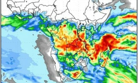
The inter-tropical convergence zone is well-demarcated across the continent occupying a wide band from just north of the equator southward to a line more or less following the Namibian Angolan border in the west through northern Zimbabwe and Mozambique, across the Mozambican Channel and on to the northern parts of Madagascar. It is visibly present over the Indian Ocean from the eastern side of the continent for a least another 5000 kilometres, passing south of India and reaching to Malaysia from where it continues north of Australia across the Pacific almost reaching the Galapagos.
The importance of the inter-tropical convergence zone lies in its proximity to Namibia. When it reaches to the Namibian Angolan border, it implies that huge quantities of moisture is situated on our northern doorstep and it only needs a small push to bring it across the border into Namibian airspace. That push is provided by the South Atlantic high as it passes Cape Agulhas and acts like a massive south to north pump up the Mozambican channel. Due to the so-called heat-low over the interior of southern Africa, the airflow recurves over Mozambique, Zambia, the DRC and central Angola. It is when this airflow comes from the north (Angola) that advection across Namibia happens. This pattern is repeated with regular monotony every ten days or so. When moisture is present over Angola, a few days later rain starts in Namibia. No moisture over southern Angola, no rain in Namibia.
This week showed the inter-tropical convergence zone to be laden with moisture, reaching right up to the border, and just waiting for the airflow to turn north.
So far the season can be described as a wet drought. Rainfall has been widespread and recurrent since just after Christmas but intensities have been low. It is only during this week, that the areas from Ruacana in the west to Rundu in the east have received substantial falls over a very wide area. These conditions were replicated across the north into Etosha, Tsumeb and Grootfontein up to the Botswana border. But the hallmark of the rainfall pattern to date has remained one of high intensities for very brief periods in scattered localities only. And it has been restricted to the northern half of Namibia with only intermittent penetration into the Kalahari along the Botswana border.
The week started with the South Atlantic high cell pressure making landfall at Lüderitz, The impact was felt over the southern half of the country for two days with nighttime temperatures on Monday and Tuesday noticeably lower than over the weekend. As the high spread across the land from the south-west, clear skies resulted. A strong convergence line formed from Ruacana across the north-eastern section up to Buitepos. North-east of this line it rained. South-west of this line it was dry.
Temperatures over the eastern half of Namibia, the whole of Botswana, the Northern Cape, western Zimbabwe, Western Zambia and southern Angola remained elevated. This can also be seen on the daily synoptic charts with a clear heat-low present over the interior of southern Africa.
What’s Coming
The battle between the South Atlantic high and the heat-low continues. The high controls conditions over the Namibian interior, at surface level until Saturday. As it slips towards the east, the airflow turn north then north-west. The impact at surface level is minimal but at the 700 mB level (9000 feet and above) it is very strong.
As the high departs during the weekend, lower pressure conditions prevail moving from Angola southward covering first the northern and north-eastern sections, then developing towards the west until the cloudiness has spread across the entire country except the coastal plain below the escarpment.
Rain is forecast to start on Sunday over the interior, then spread towards the south, with limited rainfall indicated for the southern half. These conditions continue through Monday, Tuesday and Wednesday.


