Understanding Weather – not predicting – 08 March 2013
What happened?
As this past week unfolded, the unpromising cloud situation persisted. It certainly matched what weather charts were telling us. However, there was a glimmer of hope. A slender middle layer cloud band was frequently appearing on both satellite images as well as supported by the airflow charts for the northeastern parts.
This meant there was a semblance of an input which would tap the persistent moist air presence quite close to our borders. This is not the first time this has loomed, so the optimism remained muted. By Monday, some cumiliform cloud developed by early afternoon with bits and pieces indicating active turbulence, but this was limited; still development continued. Later the cloud development was showing widespread activity with a storm area developing north of Windhoek.
Then came the lightning: a key for a real thunderstorm; There was, across a half-hour spell, continued reverberation as the storm built to levels much above those of our recent experience.
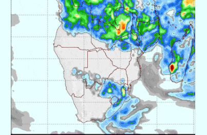
Satellite images indicated a broadening cloud intrusion above central (from north to south) Namibia while extending to the west. Intermittent outbreaks of rain were occurring within this cloud band. Overnight clearance was limited, airflow charts were showing a more profound advection. Afternoon development recurred.
This development over a number of successive days indicates a wilting upper air control, a break between anticyclonic cores supporting this pattern. Increasing middle layer moisture providing much thicker cloud bands with rather more turbulence but still short of a being true thundery sky.
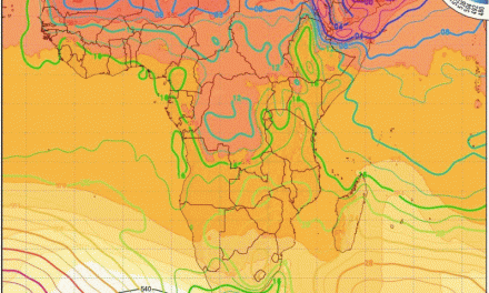
Charts showed a trough line above central Namibia, quite static despite a cold front trough crossing the Cape interior.
That some rain fell across the north, spreading into the south, was an advance on the expectations of the previous week.
What’s coming?
By weekend, two troughs pass the Cape, pushed by an anticyclonic core advancing along 40oS latitude, to establish a core at the surface and 850hPa levels, with the lean-back placing the 700hPa core above the Karoo. Only a semblance appears at the 500hPa level, but the once-controlling core will have retreated westward to mid-Atlantic.
By the new week, air flows from the east as deep as the middle cloud level, penetrating Namibian skies by Tuesday. This pattern is supported by predicted southeasterly winds at the Cape during this time. Rainfall predictions are not so promising at this stage. Tapping Zambezi air, advection in the lower levels, to advance across all but the Namib and the southwestern escarpment; the potential for shower development appears more positive.