Overview of the previous week and outlook to Friday 21 December 2018

Visual: 5-day animated precipitation forecast from Sunday to Thursday, 16 to 20 December
Source: GrADS/COLA, George Mason University, www.wxmaps.org/fcst.php
What Happened
Local conditions for the past fortnight showed very little change except for the cloud base which has come down to about 15,000 feet over the weekend.
The visual illustrates precipitation as it is expected to develop over a five-day period, providing some confirmation that overall conditions are fairly static with only minor changes to cloud base and humidity.
The weather of the past two weeks is typical for Namibia and can best be described with the analogy of a hamburger. On the surface, their is mild high pressure control over about two thirds of Namibia. This comes from the outer rim of the South Atlantic high pressure cell which pushed deep inland, sometimes by as much as 500 km or more.
It is however neutralised during the day by the sun’s energy leading to a fairly significant swing between night and day time temperatures. This effect can usually be felt up to Grootfontein.
The middle part of the hamburger is the level from about 15,000 to 25,000 feet. This is a typical inversion layer originating from the north, with a slightly lower density than the surface layer. Its relative humidity is high and it is the source of the clouds that are visible every day, but with perceptible flat tops. Convection is thus suppressed and rainfall limited.
The third layer of the hamburger is the upper levels of the atmosphere from around 25,000 to 45,000 feet, where much ridging has occurred over the past two weeks. The visual shows this very well as can be seen in the clear skies over northern Mozambique, Zimbabwe and western Zambia. Ridging is upper level high pressure control coming from the south-east as the departing continental high pressure cell influences atmospheric conditions to a considerable height.
Cloud development during last week and the weekend, followed a clearly demarcated convergence zone running across the Namibian interior from Ruacana in the north-west, in a very large curve to the northern parts of the Hardap Karas border.
This convergence zone is where the warmer tropical air from the north and north-east encounters the colder denser air from the south-west. The one slides over the other, leading to some convection but with upper air high pressure control, the clouds appear to be flat and spread out like a blanket. This prevents proper convection with the result that rainfall is very sporadic and localised.
The upper air ridging is also the source of the excessive afternoon heat. This air column sinks during the afternoon, compressing the layers below it and releasing massive amounts of energy in the process.
What’s Coming
The visual shows that rainfall expectations for this week is limited to a fairly broad convergence zone stretching from the north-west to the south-east.
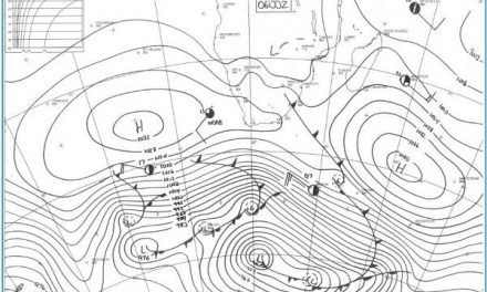
The South Atlantic high’s core is stationery about 1000 km offshore between Lüderitz and Walvis Bay. This is a bad sign for local rainfall for as long as it remains displaced so far to the north, local conditions will continue much the same as the past two weeks.
The convergence zone is expected to migrate to the east, taking the rainfall prospects away from the interior to the north-eastern quadrant.


