


The Week’s Weather up to Friday 06 October. Five-day outlook to Wednesday 11 October 2017
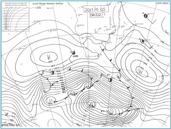
Synoptic Map: Barometric pressure and surface conditions as at 06:00 Thursday morning.
Source: South African Weather Service
Thursday’s early morning synoptic compilation gives a good view of how local weather developed during the course of the week.
On Monday, the remnants of the previous continental high was still lingering over the eastern half of southern Africa. This quickly departed to the east and early summer conditions resumed. In the wake of the departing high and amplified by the so-called heat-low that always forms over the central ground of the sub-continent, a weak trough developed, as usual, from Angola through Namibia and Botswana, into South Africa. This trough with its base roughly at 13,000 feet, advected considerable moisture into Namibian airspace inland from the escarpment but the bias remained over the east and north-east.
The presence of mid-level moisture with a relatively low cloud base was indicative of the absence of high pressure conditions. This lead to widespread but very light showers on Wednesday across Namibia’s eastern half. As this system departed, the South Atlantic high made landfall over the southern and Western Cape driving a weak frontal system ahead of it which brought cold and cloudy conditions to the Karas Region.
The synoptic map shows clearly where the 1024 mB isobar is covering the Western Cape and the cold front, the spiked line, is moving across the south of South Africa.
As is usual, only once the frontal system has moved further to the east, a cold intrusion was experienced in Namibia on Thursday but it was very brief. Because there intrusion are driven by the leading rim of the South Atlantic high, the airflow is always first from the south and then shifting to south-east and later due east, as the high itself moves to the east.
The synoptic map also shows the typical high pressure / low pressure split which divides the sub-continent in a southern and a northern half. This is a regular pattern for the transition period when the synoptic stance switches from late winter to early summer.
The map also shows that the South Atlantic high is in its customary location, perhaps a few hundred kilometres displaced to the north while the southern Indian high is in its usual place south east of Madagascar.
At this time of the year, the most consistent daily impact on local weather is the increasing number of sunshine hours and the increasing angle of the sun. Whatever comes from the south in the form of late winter cold intrusions, is quickly dispelled by the anti-cyclonic circulation and the heat-low over the centre of the sub-continent. This is primarily observed in Namibia from the cool to cold nights, and hot to very hot afternoons.
By the end of the week, the high still dominated South Africa, the earlier trough was situated over Zimbabwe and South Africa, while Namibia continued its see-saw weather typical of the season.
Of note and visible on the map, is the long southward extension of the frontal system. This means it has an affect from the continent all the way down to the Arctic circle. The overall result is enhanced north to south airflow ahead of the front and a somewhat inhibited south to north airflow behind it.
What’s Coming
The next five days will continue the pattern of very hot conditions in the north-east and cool to cold conditions in the south-west.
The outer rim of the South Atlantic high’s leading edge controls conditions over the southern Namib and the western half of the Karas Region. The weekend still sees some cooler air penetrating from the south, again with an impact that can reach as far north as Grootfontein.
By Monday, the country is split into a typical southern half /northern half pattern (cooler vs warmer) but the first vestiges of the Angolan low pressure system enters the northern Namib and starts moving down the coastal plain. General conditions will be typically early summer.
By Wednesday, low pressure conditions are expected over the southern Namib which may lead to sand storms in the Sperrgebiet.
Overall, the weekend and next week should see cooler daytime temperatures although late in the afternoons, it will go above 30°C. The areas within about 200 km of the Namibia Angola border will be very hot with the hottest areas in the west (Kunene) and east (Bwabwata and Caprivi).


