


Overview for the week and 5-day outlook to Wednesday 23 May 2018
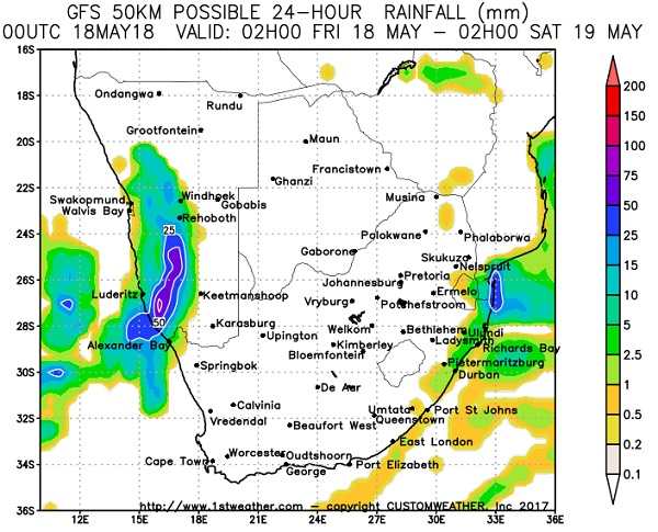
Visual: Rainfall outlook for Friday 18 May 2018 by 1stweather.com
Source: http://www.1stweather.com/maps_fx.php?wid=77107&prov=WC&metric=true&language=en&map=SYNOP#tabs-12
What Happened
Going by the regional synoptic progression of the earlier part of the week, there were little indication that this week will turn out to be so extraordinary.
At the beginning of the week, the South Atlantic high pressure cell has moved over land covering much of the Western Cape, southern Cape and eastern highveld of South Africa. Its effect was felt in Namibia during Monday but the cold intrusion was soon dispelled by the resumption of an easterly airflow. This was the result of the strong east to west zonal flow on the high northern rim.
By Wednesday this high has departed the continent leading to lower pressures over the interior of the sub-continent but not a genuine low pressure system. Barometric pressure over the eastern half of the sub-continent stayed above 1016 mB with clear skies and sunny days.
A weak low pressure system developed over the northern Namib with considerable windiness and dust as a result of the difference in pressure above and below the escarpment.
Ahead of a frontal system driven by the approaching South Atlantic high was a strong low pressure system with a marked trough about 1000 km west of Walvis Bay. This trough cut from north-west to south-east and it stayed offshore, closely hugging the frontal system.
The unexpected part came when a very well-defined cut-off low developed offshore within the broader (low pressure) trough. By Thursday it was only a few hundred kilometres west of Lüderitz, and it started showing its presence over the southern Namib. At this time it showed up on satellite imagery as a well-defined vortex with considerable windspeeds at the core.
This system made landfall late on Thursday with a wide-ranging impact over the central and southern Namib. Reports of rainfall came from Hentiesbaai in the north up to Oranjemund in the south. It remained, however, limited to the coastal plain below the escarpment.
The rainfall outlook for Friday (image above) shows how isolated the system is but with a significant impact over the southern Namib. Note also, that the rest of the sub-continent is clear indicating the presence of mild higher pressures over the sub-continent’s interior.
What’s Coming
The low pressure system quickly moves to the south during Saturday. It may still have an effect over the Karas Region with a weak northern extension in the Fish River Valley but this will be short-lived. The main area of activity lies between Port Nolloth and Saldanha Bay.
Because it is a low pressure system, it rapidly decays as it moves onland and by Sunday only a remnant of the former vortex is left over the Eastern Cape. There is some mid-level instability over the central Namib but this will probably only be seen as alto level cirrus clouds.
Next week, condition revert to an early winter stance. The first tangible sign of winter is in the strength of the southern Indian high pressure cell of which the core is expected to rise to 1032 mB. It is fortunately far removed from Namibia and the impact over the western half of the sub-continent will be zero.
By next Wednesday, the South Atlantic high sits about 1000 km west of Cape Town, also with a 1032 mB core. This indicates serious cold but the front itself is expected to miss the continent and pass south of Cape Agulhas. Behind the front follows a very strong south to north airflow which may bring to Namibia its first really cold winter weather but this will only be after Wednesday.


