Understanding Weather – not predicting – 07 December 2012
What happened?
Quite conveniently, ”weather” has chosen to make Thursdays the introduction day for new weather patterns, to coincide with the Economist publishing cycle. Since time immemorial, our understanding of weather has been achieved by our interpretation of what we can see (for a start). From this, we have built a range of experience and (with varying levels of success) interpret accordingly for the immediate future.
Thursday morning’s clouds offer a promise of not just rainy weather but more precisely thundery weather in the course of the day either over head or in the vicinity.
Such a cloud pattern forms in the middle altitudes some 8000 feet above ground level, extending upward for about another thousand feet. In our skies the air mass feeding this cloud pattern may extend upward by another 5000 feet.
This cloud is visibly turbulent. This instability provides a most favourable range into and through which lower level convection thrusts further aloft. The essence of this is, that by being so turbulent, thunderstorm development is to be expected within this air-mass. This cloud pattern, we have come to recognise, is an indicator of Tropical air advection. In our arid climate, this advection provides for a rainfall ability well beyond the expected ranges of an arid climate, in our case, again, we have yet another basis from which to describe our climate as being unique.
Yet it is fair to add that because the whole air mass is mobile, the organized pattern may depart from our overhead position before the indicated weather has developed. This does not mean that the sky has been misinterpreted but it does mean that further downwind the expectation will be fulfilled.
Such a cloud formation, either Altocumulus Castellanus or Altocumulus of a chaotic sky, are both described as precursors of thundery weather. While of interest to the ordinary observer it warns the aviation world of a serious hazard, both overhead and some distance downwind, at least.
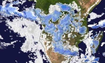
Earlier this week, such a pronounced build-up was not expected. The south Atlantic high pressure was still the dominant force but as the sea temperature rises incrementally, this control breaks down, and eventually it heralds the start of the main rain season. This is what happened during the week.
The active air-mass was pushed eastward, before a major departure could ensue. A new advection of moist air flowed overland, keeping the favourable airmass in place from adjacent Angola, into and across northern and northeastern Namibia. Consistently, thundery weather occurred over northern Namibia for much of this past week. This synoptic pattern saw heavy storms in places.:notably the far northwest, into the Namib (60mm). Whether or not this has links with the inshore Angolan warm water patch is uncertain. Local, heavy storms (70 to 110mm) occurred in the southeast: undercutting can explain such intensity.
What’s coming?
Thundery weather persists over the northern areas throughout the weekend. Further south, the pattern drifts further east, lingering until mid-week (again). A typical December rainfall pattern in fact. Daily, the heat low forms southward of the cloud band drawing in airflow from the Atlantic on the west and the subcontinent’s circulation on the east. Just how far east the system will shift, again depends on the next high pressure system drifting in from the Atlantic. Windhoek remains as usual on the convergence line with lesser expectation west and south, and better rainfall prospects north and east. But remember, as explained above, such weather always carries the potential for scattered but very intense falls, even if only of short duration.