


Overview for the week and 5-day outlook to Wednesday 25 April 2018
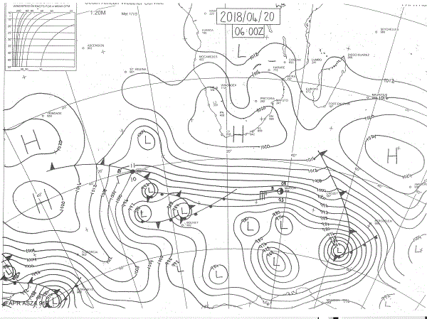
Visual: Early Friday morning surface synoptic map of the southern African sub-continent
Source: South African Weather Service, www.weathersa.co.za/observations/synoptic-charts
What Happened
Rainfall totals exceeding 100 mm for April are very rare for Namibia but with the wet spell of last week and the weekend, this is where most of the regions north of Hardap now stand. It is noteworthy that the local precipitation was matched by similar occurrences in Angola and Zambia with both the Kavango and Zambezi rivers rising by about four metres in a matter of days.
As of Tuesday, the impact of the South Atlantic high could be seen as the clouds starting breaking up and clearing from the west. For the remainder of the week, conditions remained more or less unchanged.
The Friday morning synoptic map provides a good snapshot of how events developed during the week. The main feature is the moderate high pressure cell that covers southern Namibia and South Africa south of the Orange River. Even the outer rim at 1016 mB shows clearly that, except for central Botswana, most of southern Africa became increasingly dominated by high pressure conditions as the week progressed.
High pressure control implies by definition cooler, denser air so basic physics teaches that it will tend to descend, a process that releases energy and increases temperature. However, this sinking tendency is countered the moment the sun rises and energy from an external sources starts warming both the air column and the earth’s surface. This is the reason whey cold air is usually coldest during the half hour immediately after sunrise. As energy enters the system, however slight, the air rises slowly, absorbing energy, in the process lowering the ambient temperature for a short while until the infusion of energy exceeds the absorptive latency of the air.
This is a very typical weather pattern for Namibia during the seasonal transition. The rest of the synoptic map is fairly regular displaying a characteristic early winter stance. The only feature to watch is the position of the South Atlantic high pressure cell. As the map shows, it is about 4000 km out to sea but displaced far to the north, almost on the same latitude as Walvis Bay.
During this transitory phase, local weather will be marked by cool to cold mornings, with relatively warm, even hot afternoons, as the air density first reduces, and then increases again when the sun has passed its zenith.
The question on everybody’s lips now is: Is there still a reasonable chance for any further late rains seeing that the season developed so late.
For a meaningful answer, one needs to look further afield.
Although the La Nina in the equatorial Pacific is waning, it has by no means collapsed. That portion of the ocean that formally qualifies as La Nina conditions (deviation of -0.5° C or more) still covers a very vast tract of water, some 4000 km by 3000 km. This implies that the potential impact on the rest of the globe’s weather must not be underestimated. La Nina, while decaying as a result of warmer water below the surface, is still very much with us.
This observation is corroborated by the Southern Oscillation Index of the Australian Bureau of Meteorology which decreased earlier in the week but jumped back above +13 on Thursday.
On the eastern side of the continent, the so-called Indian Ocean Transport has lost much of its recent strength and has become less defined but the area of lower pressure persists in the upper Mozambican Channel.
Together, these conditions show that it is not unreasonable to hope for one last wet spell before the season finally turns. This is also assumed by the Climate Prediction Centre in the US.
What’s Coming
As conditions are now, it will not rain. Only once current conditions change markedly to a more tropical orientation, will it be possible to tell whether there is still some late rain to come.
However, it is important to note that overall conditions for rain in the Western Cape have greatly improved and that the expected strength of these systems, once the high has departed, can easily intrude to the north as far as the Sperrgebiet and the Karas Region, or at least up to the Orange River valley.
For the weekend, the high remains the dominant feature. Nights will be cool in the south and the skies will be clear. There is no expectation for rain anywhere for the next four days.
By Monday evening the South Atlantic high makes landfall bringing cooler conditions to the south. By Tuesday there is an interesting development in the form of a so-called cut-off low just offshore Cape Town. This low can be a game changer as it has the potential to function like a huge suction pump drawing moisture from Angola into Namibia.
But it will only be during Tuesday night that the system has developed sufficient structure to make a more accurate assessment of its impact north of the Orange River.


