


The Week’s Weather up to Friday 08 December. Five-day outlook to Wednesday 13 December 2017
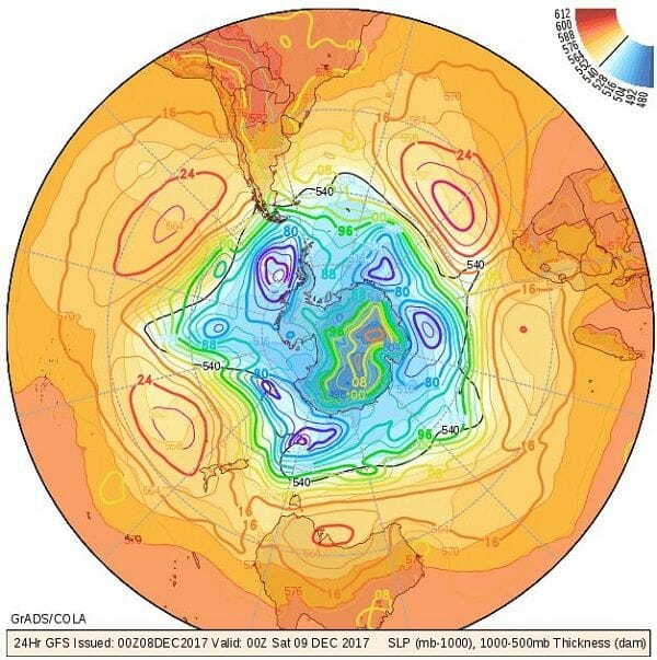
Map: 08 December 2017. Southern Hemisphere barometric pressure on the surface. Distribution of high pressure cells along the high pressure belt. Vertical depth of the atmosphere from 1000 mB to 500 mB surface. Source: COLA/George Mason University, http://www.wxmaps.org/fcst.php
The core of the South Atlantic high pressure cell has not budged. For the past four weeks it has been stuck in the same locality roughly one thousand kilometres west of Cape Town. Early in this week, its leading edge sent out a protrusion rounding the continent just south of Cape Agulhas but remaining offshore. Very little local impact was felt since the high’s outer rim at 1016 mB stayed south of the Orange River.
This pattern has been repeated for weeks. The South Atlantic high wraps itself around the continent, edging into southern Mozambique, but then the high splits with the main cell remaining just where it originated and the secondary (continental) cell quickly collapsing once it has departed the mainland.
What has changed significantly over the past month, is the number of high pressure cores in the southern hemisphere. The map shows a computer generated 2D visual of the whole southern hemisphere. The highs’ cores are shown by red lines with a reading of 1024 mB. This is normal. The anomaly lies in the almost total collapse of the southern Indian high, and of the Australian high. In total the map shows only five cores, three of normal strength, and the two very weak and small ones. Usually, especially during winter, there can be as much as seven high pressure cores circling around the southern hemisphere.
When the number of cores is reduced, like this week, the distances between the cores become bigger. In Namibia’s case, this has a major impact for it is these “open” areas between the cores that creates a 4 or 5-day window. During this period the high’s dominance from the south is diminished and there is room for tropical air from the north to penetrate deep into the south. Were the highs of normal number and strength, these windows will be non-existent, or very brief, maybe 24 hours or even less.
The relatively large opening between the southern Indian high and the South Atlantic high drove much of Namibia’s weather for the week. Once the continental high has departed on Tuesday, low pressure conditions set in over the western half of the sub-continent. By Wednesday, a low pressure system was in control over most of Namibia, the Northern Cape and the Western Cape. This allowed warmer, moist air to flow from Angola across Namibia into the South African interior. The result was widespread cloudiness from Wednesday onward.
Substantial rainfall was recorded in the North, along the Botswana border and the area between Windhoek and Witvlei. A few sporadic falls were recorded further south into the Kalahari. A particularly strong downpour was reported from the Stampriet district with small rivers flowing in that vicinity. But overall precipitation was still restricted to isolated systems spread over a very large area in the north-eastern quadrant.
With the airflow predominantly from the north, a well-demarcated convergence zone formed from southern Angola through Namibia and into southern Botswana. All the rainfall occurred east of this zone.
What’s Coming
The feature to watch is the number of high pressure cores in the southern hemisphere and the distances between them.
While cloudiness will continue over the Namibian interior over the weekend, cloud formation is not expected to be robust, and by Tuesday, the last rain of the current window will be gone.
For most of next week, the approaching South Atlantic high will exert the biggest control on the surface. However, airflow in the upper air will remain anti-cyclonic, again leading to a fairly broad convergence zone. Unfortunately for us, most of this activity is expected over Zambia, Botswana and South Africa, so it will only be with some luck, that some of the moisture penetrates the Namibian interior.
Going by current conditions (as indicated on the map), there is a significant gap between the two highs east and west of South America, and if that remains the case until the next South Atlantic high reaches the west coast, there may be an even bigger 5-day window for penetration from the north.


