


Weather overview and short-term outlook to Wednesday 23 September 2020
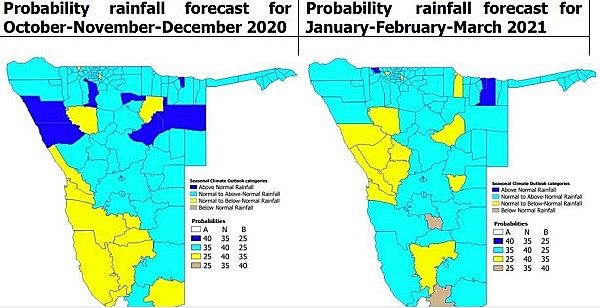
Visual. Rainfall probability forecast, October 2020 to March 2021.
Source. Ministry of Works and Transport / Agribank Research Department.
Recent Developments
The official advisory from the National Oceanic and Atmospheric Agency (NOAA) of the US Government, released last week Thursday, has changed to “La Nina conditions are present.” Although it still does not designate an official La Nina event, the chance of La Nina conditions continuing for the austral summer, has now improved to 75%.
This week’s visual shows the official probability forecast for the upcoming local season. This type of forecasting is very conservative, reflecting the meteorologists’ awareness that weather forecasting is a precarious undertaking. Still, both three-months seasons show a preponderance of light blue shading which indicates normal to above normal rainfall expectations.
For the past two weeks, local weather followed a regular early-summer pattern with a weak mid-level trough over the Kavango amplified by low pressure conditions over Botswana and central South Africa. This week also saw the first appearance of the season of the so-called heat-low which typically forms over the wider Kalahari basin with Bwabwata as the centre. Coupled with an easterly to north-easterly airflow, it caused very hot conditions in the Kavango and the regions north of Etosha.
This was offset over the southern and central areas by the outer rim of the South Atlantic high pressure cell which ridged into Namibian territory following more or less the route of the Fish River. It lead to cooler early mornings in the first half of the week but nothing that can be described as cold.
By the end of the week, the mid-level trough has shifted to the Botswana Zimbabwe border and Namibia enjoyed mostly cloudless days with only a hint of moisture in the upper layers of the atmosphere.
The weather is in that inter-seasonal see-saw pattern where the power of the South Atlantic high is displayed for brief periods, most noticeable at night, and then replaced by the combined effect of solar heating during the day and a steady airflow from the north.
On the Radar
The relatively settled conditions continue during the weekend with little expectation of much moisture intrusion from the north.
The South Atlantic high approaches the continent and by Sunday evening, nighttime conditions in the two southern regions should be somewhat cooler. This will result in wind from the south-west indicating cooler, dry conditions over about two thirds of the country.
It is only be next week Tuesday, when the South Atlantic high has shifted eastward to morph into the intermittent continental high, that a strong anti-cyclonic circulation resumes. This will bring in moisture from Angola with the result that clouds will start developing over a large part of central Namibia, following the convergence zone that will develop from north-west to south-east.
As of Wednesday, there is a slight chance for light precipitation over the interior with the probability of somewhat heavier showers along the Botswana border adjacent to the Kgalagadi Transfrontier Park.


