Weather 21 August 2015
![]() What Happened
What Happened
The week started with a sedate South Atlantic high pressure cell of moderate strength lying due east of Oranjemund. The cell’s outer rim had a surface impact over the southern half of Namibia as witnessed by the continuing colder nights. The cell’s core, slowly weakening as the week progressed, sat some 2000 km offshore.
South-east of the continent, a fairly strong vortex has developed over the previous weekend, gaining in intensity during the week. This area of very low pressure and strong cyclonic circulation dissipated the cold front that passed south of Cape Agulhas early in the week. As such, it ensured that the cold intrusion remained restricted to the most southern limits of South Africa, but it also weakened the south to north airflow. This pattern has repeated itself numerous times during the winter.
As the system migrated to the east, the South Atlantic high slowly enveloped the Cape coastline, while the core moved closer to the continent. By Thursday, the synoptic map showed a subdued South Atlantic highs with a core reading of 1028 mB situated about 1000 km west of Port Nolloth. Around Cape Agulhas the high has pushed out an elongated bulge, circling around the continent and reaching the southern Mozambican Channel by Friday. Again, this acted as a buffer preventing any significant cold intrusion, and the cold front slipped past the southern Cape without much continental effect.
Further north however, a prominent continental anti-cyclonic circulation showed on Monday and Tuesday with its epicentre over eastern Zimbabwe. This continental anti-cyclonic circulation opposed the intrusion from the south by the South Atlantic high. This creates the typical late-winter seesaw conditions on the surface. When the sun is up, barometric pressure drops quickly, the airflow is from the north to north-east, and the day becomes warm. The moment the sun sets, the irradiation energy is removed, the pressure increases, the windflow changes to southerly, and the outer rim of the South Atlantic high controls the night.
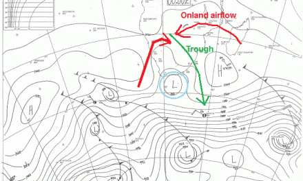
A very prominent convergence line started developing during Wednesday stretching from offshore Swakopmund across the country to the south-east, and deep into the South African interior.
Wednesday night, light rain fell at Ariamsvlei. It is this same system that is expected to develop backwards and bring cool and wet conditions to the Karas Region, and perhaps to the eastern section of Hardap as well.
What’s Coming
A meaningful assessment of the weather for the next four days can only be made by observing the 1016 mB isobar on synoptic forecast maps. This barometric line is an imaginary line. In reality it does not exist but as an analytical tool, it is of immense value to meteorologists.
The 1016 mB line always intrude from the south. South of this line, high pressure reigns while north of it, lower pressures developed. As the outer rim of the high pressure cell migrates across the subcontinent from west to east, this line warps and buckles under the influence of local conditions, airflow, and solar irradiation.
By Friday evening this line cuts across the middle of Namibia from the Atlantic to the Botswana border. By Saturday it has shifted further south and the whole country will be subject to lower pressure conditions. This should show up as haziness on the horizon, a condition well-known by pilots and exacerbated by smoke when veldfires erupt.
By Sunday, the high has shifted to the east creating typical August conditions, i.e. higher pressure over eastern Africa with airflow from south to north, while in the western half, which includes Namibia, the exact opposite develops – lower pressure, light wind, warmer conditions and airflow from the north.
By Monday next week, a weak trough develops, as is customary from the Kunene mouth, south-eastward across Namibia to the Orange river valley and again deep into the South African interior. In the wake of this trough, much lower pressure follows and by Tuesday, the barometric pressure will drop to 1012 mB in the far north from Nkurunkuru across Owambo to Ruacana. It will be very hot in this vast area. All it needs is a vortex in the Mozambican channel and we are set for an early rainfall surprise.