


Weather 08 April 2016

What Happened
A complex synoptic map at the beginning of the week only got more complex to the end. The reciprocal oscillation between South Atlantic cold and tropical heat painted a vivid canvass with daily temperature moves of more than 25oC and an active convergence line where the opposing systems met.
On Monday, the South Atlantic high pressure cell had just made landfall on the western coast and the southern Indian high was in its expected position some distance south-east of Madagascar. But between these two highs, a strong vortex started developing. As the week progressed, the South Atlantic high surprised with the speed it crossed just south of Cape Agulhas and how quickly it moved up the Mozambican Channel. Equally surprising was the intensity of the vortex. With a core reading only 996 mB, it came close to storm intensity.
The west to east migration of the high across southern Africa lead to high pressure control over the eastern half of the subcontinent. Unseasonally cold conditions in South Africa were the result of this control. Over Namibia it split the country again into a western half and an eastern half. In the wake of the migrating high, a low pressure system developed in southern Angola which moved southward along the coastline covering both the northern and the southern Namib. While the high over South Africa and the Mozambican Channel measured an impressive 1032 mB, the coldest so far this autumn, the low along Namibia’s coast, went down to 1008 mB.
The large pressure differential caused a pronounced airflow from east to west, modified by the rotation of the high. The result was a week with considerably warmer night temperatures compared to a week ago, and a very well demarcated airflow from north-east to south-west on the surface level. This influx of warmer, moister air occurred every day this week, leading to very unstable conditions over the north-eastern quadrant, visible cloud formation, and some spectacular falls from Kavango West all the way down to the Orange River.
The airflow gradually backed from north-east to north, and later to north-west over the Kunene and Erongo regions. It also caused classic diabatic compression over the coastal plain with high day temperatures over both northern and southern Namib where it was accompanied by windy, dusty conditions.
Towards the end of the week, the high over the eastern half of the sub-continent has moderated somewhat to about 1020 mB while the low pressure system over the western half of Namibia has subsided to around 1012 mB. The smaller pressure differentials leads to quieter days, but during the night fairly strong windy conditions can be expected to continue over the escarpment and the coastal plain.
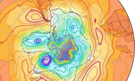
An anomalous feature is found in the upper air. While the airflow on the surface is mostly from the north-east, the upper level airflow is markedly west to east. This is an indication of some high pressure control lingering in the upper levels. While the warmer surface air is good for rainfall expectations, the high control in the upper air suppresses convection which in turn, limits rainfall.
What’s Coming
By Saturday, the Namibian weather is still split into a western and eastern half. The high low split remains a synoptic feature during the weekend. However, the north to south airflow over Namibia continues to advect moisture from Angola, so there remains a small chance for very light falls over the interior.
The synoptic feature to watch is the next South Atlantic high pressure cell. During the weekend it is still very far out over the Atlantic but ahead of it another vortex is expected to develop. This vortex will enhance the north to south airflow over Namibia, but the forecasts are unanimous that rainfall expectations for next week are rather dim. It is only by next weekend that the combination of moisture from the north, and the rotational push from the south, could create conditions for a surprising late season intrusion of moisture.
With the Indian Ocean still some 1.5oC above normal, and a marked zonal flow over Mozambique, Zambia and Angola, there is still a reasonable chance for moisture to enter Namibian airspace.


