


The Week’s Weather up to Friday 29 September. Five-day outlook to Wednesday 04 October 2017
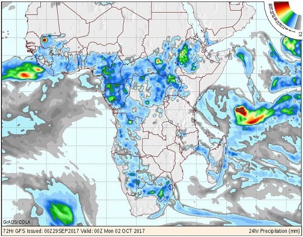
Map: 12-hour precipitation forecast for Sunday 01 October 2017. The map indicates expected conditions for the 12-hour period preceding the date at the bottom of the map. Source GrADS/COLA, George Mason University.
As the season passes the equinox, the sunshine hours per day exceeds the 50/50 split meaning the period of energy infusion is longer than energy depletion. In short, the southern hemisphere slowly gets warmer as it receives more energy during the day than what it radiates at night.
Of course, the weather is not so simple. The sun’s angle also changes every day and the amount of terrestrial energy that remains is influenced by active systems, both close to the ground and higher up. The interaction between these systems is extremely delicate and the slightest change in values have a rather dramatic impact on how the weather develops in any particular spot.
At the beginning of this week, the South Atlantic high pressure cell made landfall over the South African west coast. This brought a cold intrusion to the Western and southern Cape regions but it was only a day later, on Tuesday, that it reached southern Namibia. By this time, the high had covered most of South Africa south of the Orange River and it has advanced to a position over the eastern highveld. This is the reason why cold intrusions seldom impact Namibia directly from the south. It is only when the high has shifted far enough eastward that the anti-cyclonic circulation with it pivot over Botswana, brings the cold air back, so to speak.
In Namibia the weather then displays a distinct dichotomy. Over the northern half conditions are controlled by the tropical system present over Angola and Zambia, while the southern half is under the influence of the high to the south-west, south and south-east. The line where the two systems meet is always in flux, continuously modified by the airflow from the north, and shifting its position as it is driven by the jetstream in the upper atmosphere.
All these elements were displayed during the week.
A cold front passed the Cape but with limited impact over land. A weak cold intrusion on Tuesday night followed the regular pattern of first coming from the south and then, as the high migrated across the sub-continent, recurving from Botswana and coming from the east. Only the eastern half of the Karas Region was really affected although cooler conditions were also noted further north along the Botswana border. Wednesday morning was noticeably cooler even as far north as Otjiwarongo.
Although the cores of the South Atlantic high and southern Indian high were in their customary positions either side of the sub-continent, both were relatively weaker at 1024 mB. South of the continent, a very well-demarcated and strong trough developed but the impact over land was restricted. Still, the trough functioned like a huge vacuum cleaner, siphoning the brunt of the cold front away to the south. This also limited its impact over the subcontinent and weakened its northern reach.
Over Namibia, a weak middle level trough developed around Wednesday. Tentative scattered clouds appeared but were suppressed by high pressure conditions in the upper levels. Consequently convection was absent despite surface level humidity elevated at about 30% for most of the eastern half of Namibia. The only significant convection took place in western Botswana just outside Namibian territory.
On Friday there was some unstable air present between Hosea Kutako International Airport and Witvlei with a promising system developing on infra-red satellite images but precipitation has not been confirmed.
What’s Coming
The map shows expected precipitation for Sunday. From this image it is also clear that high pressure conditions continue to dominate eastern Africa. The map also reveals that a weak and dispersed convergence zone forms over Namibia during Saturday, covering most of the country by Sunday, with a pronounced north-west to south-east airflow.
Overall conditions are not conducive for rain but local falls are possible.
The presence of the trough is brief and by Monday the upper air systems has driven it to the east over Botswana. A cut-off low is expected to form just ahead of the next approaching South Atlantic high but its effect will be limited to south of the Orange River.
By Tuesday, a very regular early-summer pattern is in place with a weak trough from Angola crossing Namibia into South Africa.
Another convergence zone forms with cooler, dusty conditions over the south-western quadrant and hot, stifling conditions over the north-east. The battle between north and south continues and by Wednesday the country is neatly divided into a northern and southern half. Cool to warm in the south and hot to very hot in the north.


