


The Week’s Weather up to Friday 15 December. Five-day outlook to Wednesday 20 December 2017
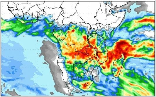
Map: Expected accumulated rainfall for southern Africa from 15 to 22 December.
Source: COLA/George Mason University, http://www.wxmaps.org/fcst.php
The forecast rainfall map for the next week shows a close correlation to the updated seasonal rainfall expectations prepared by the SADC Climate Services Centre for the three-month season from January to end of March 2018.
Although the featured map is for one week only, it shows a remarkably similar distribution to the three-month forecast maps. The reason is the current strength and locality of the South Atlantic High pressure cell indicating that the seasonal outlook bargains on the fact that the high will remain more or less in the same place for the duration of the Namibian main rain season, and that it will continue to exert the same influence.
The core of the South Atlantic high has been stuck in the same position some 1000 km west of Cape Town for the better part of six weeks. Its stationary location presents a clear anomaly since the typical pattern in summer would be to swing around Cape Agulhas and to continue on the other side of the continent as the new southern Indian high.
This has not happened. The sedentary South Atlantic high has regularly, almost every week bulged towards the continent, sending out a high pressure protrusion that enveloped the southern Cape and morphed into a relatively weaker high south of Madagascar. The result was southern Indian highs much reduced in strength and prone to total collapse as has happened on three occasions.
The mother cell, the proper South Atlantic high, has retracted every time after splitting off the migratory (weaker) high, and has reformed without fail as a stronger South Atlantic high, the core all the while staying more ore less in the same sedentary position from where it impacted the weather in the Western Cape, Northern Cape, the Karas and Hardap regions, and on one occasion, the interior of Namibia when the unexpected, unseasonal cold spell penetrated deep into Namibia despite the winter being long gone.
This week, the same sequence of events played out again with almost textbook precision. The South Atlantic high sent a protrusion around Cape Agulhas which lingered for two days over the eastern parts of South Africa and over southern Mozambique. But the mother cell retracted again and by the end of the week, was still in situ with a marked influence over Namibian weather.
This means that lower pressure controlled the southern African interior with a marked anti-cyclonic air circulation but along the west coast, on the surface at least, higher pressures were very much in control. This cleared the skies of any cloud on Wednesday and Thursday, with only a restricted intrusion on Friday.
Precipitation only fell in the north-eastern quadrant and only very sporadically. A well-developed convergence zone ran across Namibia along the customary track from the North across Otjozondjupa and Omaheke into the central Kalahari. Significant showers only occurred east of this line. In the south-western two thirds of Namibia, high pressure control on the surface remained the dominant factor, preventing any meaningful rain.
What’s Coming
By Saturday, the weak continental high has departed leaving most of the subcontinent’s interior under low pressure control. However, the offshore position of the South Atlantic high remains an important factor and over the weekend, the 1016 mB and 1012 mB isobars are in relative close proximity, divided only by the escarpment. This should lead to strong winds from west to east up the western face of the Khomas Hochland.
The interior is dominated by low pressure control with a marked north to south airflow from Angola into Namibia. This should bring substantial cloud formation but at a fairly high altitude (around 12,000 feet or higher). The interaction between the two system again creates a well-demarcated convergence zone and there is some hope for light showers over the eastern half of Namibia, from north to south.
Next week sees a repeat of the same pattern that emerged this week. The only unknown is how far to the west the convergence line will shift. The further west, the better the chances for rain over the interior. The most reliable rainfall forecasts are unfortunately not in agreement, and much can happen during Monday and Tuesday.
There is general agreement that the South Atlantic high will remain stuck for the next five days so by Wednesday, it should start again to clear the interior. The only exception is the north-eastern quadrant. Being east of the convergence line, it is the only part of the country with a reasonably positive rainfall outlook. Similar to this week, local conditions depend on how far west the convergence line will shift.


