


The Week’s Weather up to Friday 28 July. Five-day outlook to Wednesday 02 August
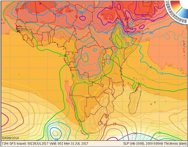
Map: Isobars at surface level and the vertical distance between 1000 mB (sea level) and 500 mB (around 18,000 feet) in colour shaded areas. Forecast for Sunday 30 July 2017. Lighter areas indicate a lower 500 mB surface (thinner atmosphere) while darker colours indicate a higher 500 mB surface (thicker atmosphere). Source: GrADS/Cola.
The main feature of this week’s weather is the extended high pressure cells around the southern hemisphere. There are still only four major core areas with relatively large distances between the cores. This space has been invaded by the outer fringes of the high pressure cells leading to elongated, expansive cells covering vast distances of the southern hemisphere oceans.
It is best seen in the southern Indian high pressure cell which grew in extent as the week progressed. By Friday it formed on continuous cell from Perth in Australia westward across the ocean to the South African highveld. On the subcontinent’s western side, lower pressures were in place but only a few hundred kilometeres offshore, the South Atlantic high pressure cell started and it reached all the way to the Argentinian coastline in South America.
When the highs disperse over such vast areas, they form contiguous zones preventing air to flow from north to south or vice versa. It is only on their leading and trailing edges that frontal systems can develop and it is only in these very narrow, restricted funnels where tropical air is convected into the colder climate in the south, or cold antarctic air is transported north into the warmer zones.
In effect, the large, expansive high acts like a cushion, buffering the southern African sub-continent against a direct blast from the south.
A very strong frontal system developed some distance out to sea over the Atlantic but the trailing edge of the high over the sub-continent, drove the approaching front southward. Two lesser cold fronts ahead of the mammoth system crossed south of Cape Agulhas during the week but the high’s buffering effect prevent them from making landfall.
The combined result of all these elements is a very mild winter. While the nights are cold due to the presence of the high pressure cell over the sub-continent, the transport mechanism that normally would have brought intensely cold air from the south onto the mainland, is prevented from functioning.
Coupled with the increased number of sunshine hours per day, now just over 11 hours, and the sun’s angle that also increases by a few degrees per day, the weather shows the typical late-winter see-saw pattern.
Nights are cold because the air in the high pressure cell is cold, but during the day the increased solar energy quickly warms up the entire sub-continent. Another observable phenomenon is the direction of the airflow on the surface. During the night it backs from south-west to south-east but as soon as the sun is up, it swing around to north-east.
Since the high pressure cells always migrate from west to east, it means that the air travels a much longer distance during the day over the mainland, giving it ample opportunity to get warmer. It is best observed in Namibia’s north-western corner (Kunene Region) where the afternoons easily reached 30°C during the week. This is the result of air heating up as it travels over land, in this case from Mozambique across Zimbabwe, Botswana and Zambia before entering Namibia from the north-east. It has a long time and long terrestrial distance to get warmer.
The overall picture in Namibia presented a marked difference between conditions in the northern half compared to the southern half. Especially in the south-east up to Aminius conditions were noticeably cooler than the rest of the country. However, even here where nighttime temperatures went down to 2°C, the days quickly became warm, comfortably reaching 24°C in the afternoons.
What’s Coming
The continental high departs over the weekend while the core of the next approaching South Atlantic high is still some 3000 kilometres offshore. A very strong depression develops ahead of the high’s leading edge, as shown in the map.
By Sunday a so-called cut-off low sits about 600 km west of Cape Town. It collapses within 24 hours but it has the effect of bringing low-pressure conditions to Namibia.
This system is expected to bring rain to the Western Cape on Monday and Tuesday but the local effect is to create a strong north to south airflow. This may even bring some cloud to the Namibian interior from Tuesday onward.
The strength of the high’s leading edge is eroded by the collapsing cut-off low, and it slips around Cape Agulhas by Tuesday night. For the three days, Monday to Wednesday, conditions over Namibia’s interior may be windy, especially during the night, but the days will continue to get warmer.
With the absense of large pressure differentials, no Oosweer is expected.


