Understanding Weather – not predicting -14 June 2013
What happened?
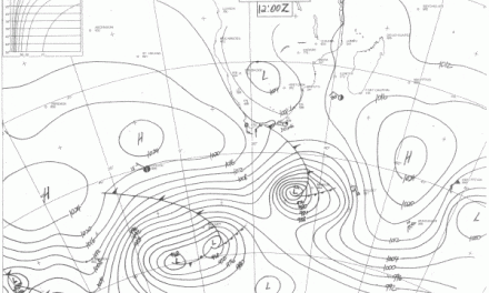
A cold front, driven by a ridge (high pressure cell) was followed by a second, weaker cold front which penetrated far across the southern part of the continent. This brought the first real winter conditions to Namibia and is lasted the entire week.
The prominence of secondary vortex recurrence, quite frequent these days, may seem unusual within cold air in circulation behind a departing vortex core, but the cold inflow is often unstable with a lapse rate steeper than the standard 3o per thousand feet. Such instability quickly forms conflicting airflows battling each other leading to stormy winds from surface level to several thousands of feet aloft. These vortex cores are most prominent above the oceans. Their influence weakens by the time landfall is made. Their effect on weather systems is much broader, though, as the now well-developed core with equally active frontal troughs advances eastward. Namibia is usually limited to the extremities of the cold front and its ability to bring very cold conditions in the rather narrow turbulent air belt immediately behind. Therefore their local duration is short, and two days of intense cold is soon replaced by three days or more, of milder temperatures.
These occasions provide the basis of our winter rainfall zone in the south, more or less south of the line running through Lüderitz and Keetmanshoop.
Both, the original and the secondary, systems can host a trailing cold front which provides a base for a cut-off vortex. Recently this kind of development has gained a stronger base in the upper air, several thousands of feet above the surface and with considerable upward extension.
What’s coming?
With a zonal flow holding sway for the next few day, the weather patterns assume a quiescent mould where our skies are concerned. Higher pressure to the east keeps air flows with a northerly bias for the weekend and into the new week.
More distantly, a well-marked trough (low pressure) appears on the surface stretching into the upper layer. This succession of colf front, each about four or five days behind the other, marks a very typical winter pattern and it can now be expected that extremely cold spells will last about two days before the wind direction returns to north, bringing milder conditions across the country.
The approaching cold front makes landfall on Sunday, leading to a cold early part of the week. Windflow backs around to North again by Tuesday, relieving the cold over the northern half of the country but the south will remain crisp. It will now get progressively colder up to the second week of July.