


The Week’s Weather up to Friday 30 June. Five-day outlook to Wednesday 05 July
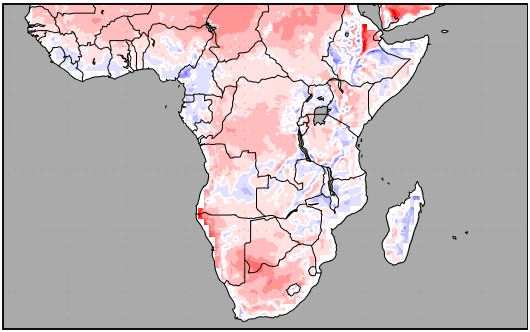
Mean Temperature Anomalies for the period Friday 30 June to Saturday 08 July 2017
Source: wxmaps.org, GrADS/COLA
The three weeks after the winter solstice are known as the coldest part of the southern African winter. There is little agreement amongst scientists why this happens, but meteorologists agree that it has much to do with the relative latitude and strength of the South Atlantic and the southern Indian high pressure cells. The map above shows that for the next week, although it is winter, mean temperatures are expected to be higher than normal, meaning no frost over Namibia.
The synoptic progression for the week shows the migration of the South Atlantic high as it moved across the southern Cape and settled over the high ground of Lesotho. By the middle of the week, this high has connected to the departing southern Indian high forming an elongated cell stretching from the African continent to midway across the Indian Ocean with two distinct cores, one over the main land and another, about 2000 km further east over the ocean. The pressure readings in the cores were elevated, coming in at 1032 mB but the core over the ocean was displaced far south, straddling the 40°S lattitude. This indicated, that while the cells were strong, their impact on the continent were reduced due to the distance away.
On the western side where the South Atlantic high always reign supreme, the core is of normal winter strength at 1024 mB but displaced to the north, more or less in line with Walvis Bay. Since this high is in much closer proximity to Namibia, its effect is more direct. Windy conditions over the interior together with cloudiness and a substantial drop in temperature during Wednesday night, are testimony to its effect.
However, the air circulation on the surface continued its now familiar anti-cyclonic circulation with the result that whatever effect the high had during the night, it quickly dissapated when the sun rose. Helped along by the north-easterly airflow from Zambia and Angola, it brought in warmer tropical air leading to warm, pleasant afternoons despite the dip in night time temperature. The effect of this tropical air is also revealed by humidity readings which varied during the week between 30% and 40% over the interior depending on elevation. The humidity is anomalously high for winter. The normal relative humidity in Namibia during winter is typically below 12%.
By the end of the week, the system of highs has split into three distinct cells, the southern Indian, the South Atlantic and between them, the continental high over the eastern and southern parts of South Africa including Lesotho.
What’s Coming
The weekend starts with the departure of the southern Indian high away to the east, in the process pulling the continental high with it. (It must be remembered that the continental high is a transitionary cell that forms over the interior plateau as the South Atlantic high morphs into the southern Indian high.)
The core of the South Atlantic high is still on the same latitude as Walvis Bay and its reading stays flat at 1024 mB. It lies about 2000 km offshore.
The expected synoptic pattern for the next two days is rather static with the South Atlantic high moving across the southern Cape by Sunday evening, much like this week.
It is only by Monday that a change of scenery occurs. As the South Atlantic high moves across the main land and settles over Lesotho, there is a clear break between it and the next approaching South Atlantic high.
A well-developed low pressure system lies between these two highs, and by Monday it is only about 500 km west of Cape Town. The substantial pressure differential between the cut-off low and the next South Atlantic high creates a signature frontal system which will be approaching the Western Cape on Tuesday.
The cut-off low is situated just ahead of the frontal system, bringing cold air across Namibia from the south-west, but also spilling over the winter rainfall system into the southern Namib. It is not expected to produce any precipitation over the Sperrgebiet and Karas Region, but it should lead to substantial cloud formation.
By Wednesday, the whole subcontinent is under high pressure control except the Namibian coastal plain, which is still affected mostly by the cut-off low. This large pressure differential will bring very windy, unpleasant conditions to the entire escarpment from north to south, with a strong possiblity of sandstorms over the southern and central Namib. Over the northern Namib, it will be more conventional Oosweer.


