


The Week’s Weather up to Friday 24 March Five-day outlook to Wednesday 29 March
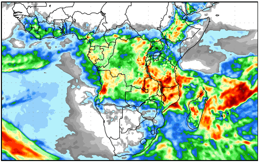
Precipitation forecast from Thursday 23 March to Friday 31 March
Source: wxmaps.org, GrADS/COLA
The weather across the sub-continent is divided into two opposing zones. North of the Orange River latitude, summer conditions are still strong, while south of this line, early winter conditions are showing up in the synoptic charts.
In particular, the location and spacing of the two dominant high pressure cells, the South Atlantic and the southern Indian, show a typical early winter pattern. The presense of well-developed frontal systems between the successive high pressure cells, is a further confirmation of wintery conditions. At present, both cell cores lie across the 33°S latitude, a position they would normally occupy during winter, and some 500 km north of where they were for most of the summer, despite their frequent wandering.
A further sign to support the notion of an early winter, is the core strengths. While the cores have frequently collapsed over the past two months, during the early part of this week, both read 1024 mB. That is normal but towards the end of the week, both cores have increased in intensity, reading 1028 mB with a small part inside the South Atlantic high’s core, reading 1032 mB. These high barometric readings are indicative of very quiet, dense and cold conditions on the surface.
The South Atlantic high was slow to approach the continent during this week. The core remained offshore but the outer rim at 1016 mB made landfall on Thursday, bringing cold conditions to the Western Cape and the southern Cape region. In Namibia the result was cooler conditions over the south with a marked southerly airflow over the interior. The intense Oosweer conditions at the coast also abated as the southwesterly winds picked up.
While all this played out over the southern half of the sub-continent, the northern half was still very much controlled by a summer stance. The airflow on the surface was predominantly zonal, moving from east to west, from the Mozambican Channel across Mozambique, Zimbabwe and Botswana into Namibia. This brought cloud to the Namibian interior on a daily basis. A well-developed area of low pressure developed from Angola southwards along the coastal plain, leading to a marked differential between higher pressure over the interior and lower pressure over the Namib. When the easterly aiflow reached the escarpment, it entered a convergence zone at the middle levels of the atmosphere, around 12,000 feet and higher. A band of rainy activity followed, stretching from the Kunene all the way south along the escarpment to the Orange River, and eastward across the interior up to the Botswana border. It even developed into the eastern sections of both the Hardap and the Karas regions.
Another effect of the easterly windflow was a sustained high vapour load. In most places in the interior, relative moisture remained around 50%. This is usually a good sign as it indicates the possibility of rain when convection is at its highest in the late afternoon. These conditions were present across the entire country except the central and southern Namib.
What is Oosweer
Spoiling the Independence weekend for the people in Swakopmund and Walvis Bay, was an intense wave of Oosweer lasting almost three days. With temperatures going to the low forties, conditions on the surface were certainly not pleasant.
Oosweer is the local version of so-called Bergwind conditions. This happens when air flows from a higher to a lower elevation, in our case from east to west. When that air descends down the western face of the escarpment, the same volume of air now has to occupy a smaller space since the earth is a globe. The descending air compresses, releasing energy which is felt in the rise in surface temperature. It is the most important reason for hot conditions in the desert during winter. Pilots know it as a katabatic wind while meteorologists call it diabatic compression.
What’s Coming
The northern southern split across the sub-continent becomes more pronounced during the weekend.
The South Atlantic high, still offshore on Friday, slips around Cape Agulhas on Saturday and Sunday. Its core remains barely offshore. The 1016 mB isobar covers South Africa up to the Orange River in the west and Swaziland in the east. There is a reasonable expectation that Lesotho may get its first snow, in which case, colder weather will enter Namibia from the south-east.
By Monday, the high pressure cell is located south of the Mozambican Channel, with another low pressure area forming over the Namibian coastal plain.
Tuesday sees a repeat of the high low pressure differential, leading to mild Oosweer over the central Namib. This intensifies overnight and by Wednesday Oosweer should be present from the Kuiseb to the Kunene.
Rainfall is only indicated on Saturday and Sunday over the northern half of the country with the bias over the Kunene Region. No rainfall is indicated for Monday, Tuesday and Wednesday with the only possible exception, the Kunene Region close to the Kunene River.


