Weather 25 November 2016
What Happened
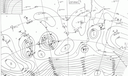
This week it was the South Atlantic high pressure cell’s turn to collapse. The week started with a very weak South Atlantic high, down to just 1016 mB with a poorly defined core about 1000 km west of Oranjemund.
In contrast, on the continent the so-called heat-low continued its presence over southern Africa with a strong anti-cyclonic circulation which advected loads of moisture from Angola into Namibian airspace.
To determine the atmospheric difference between high pressure and low pressure, the most reliable indicator is the height of the cloud base. When high pressure reigns over Namibia the cloud base is typically above 16,000 feet and sometimes as high as 22,000 feet. When low pressure conditions intrude from the north, the cloud base rapidly descends to around 10,000 feet.
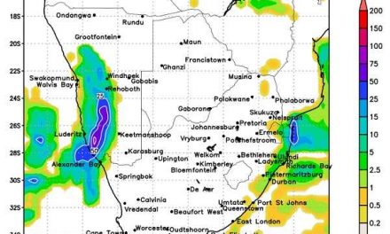
The widespread rains of Monday continued through the night and into Tuesday. At one point, the cloud base was around 9,000 feet. Visually, the influence could be seen in the cloud type – fluffy white clouds that seem to form and disappear some distance below the ordinary cloud base. This is unstable tropical air at work.
The airflow from north to south was further enhanced by a so-called cut-off low that developed just offshore from Cape Town. This cyclonic circulation amplified the push from the north, as witnessed this week by moisture penetrating even the southern Namib.
By Wednesday, conditions have become more conventional with a very well-defined convergence line running from Ruacana southeastward to Aminuis. The cloud base had risen to around 14,000 feet but a prominent low pressure trough remained at around 18,000 feet. This produced some spectacular CB development which can only happen if convection is enhanced indicating a lack of high pressure control in the upper air.
The Inter-Tropical Convergence Zone keeps increasing in strength over Angola and the DRC but the atmosphere over East Africa remains fragmented. However, the so-called Indian Ocean Dipole has turned neutral from negative so there is a reasonable expectation that the ITCZ over East Africa will grow stronger, or at least less fragmented. When the Indian Ocean is cooler than normal near Africa and warmer than normal south of Indonesia, the Dipole is negative. When reverse conditions set in, it is positive. The Indian Ocean Dipole has been negative for almost a year, i.e. cooler water near Africa, which was a major contributor to the drought in southern Africa.
Except for the Western Cape’s rainfall areas, the whole southern African summer rainfall area gets its moisture from the Indian Ocean in a long detour that covers Tanzania, northern Mozambique, southern DRC, Zambia and Angola. If the moisture conveyor is obstructed at its continental point of entry, southern Tanzania and northern Mozambique, the whole subcontinent suffers from a lack of sufficient moisture in the middle and upper levels.
When the Dipole turns neutral from negative, the first indicator is a rise in altitude of the 500 mB surface and a thicker atmosphere. While this is not yet the case over East Africa, over the Indian Ocean north of Madagascar, it is already happening.
What’s Coming
By the end of the week, the South Atlantic high has regained some of its composure but remains weaker than usual. During the weekend it departs to the east, making space for a low pressure intrusion from Angola. Sunday will see a strong northerly airflow with much cloud formation, again across almost the whole country. Upper air conditions, however, are not favourable and convection will be suppressed. The outlook is only for isolated showers and again with a wetter bias in the north and north-east.
The low pressure intrusion from the north continues into next week. By Monday it will be blisteringly hot over the central and southern Namib. This shifts across the Karas region to the Kalahari along the Botswana and South African border by Tuesday.