Understanding Weather – not predicting – 15 June 2012
What happened?
Just how future historians will come to assess the current years requires contemplation; for certain there is no shortage of grist to the mill. Across a very brief period of time mankind has come to describe the weather world in which we live. Having put fact to figure and figure to fact, the written record, we stood back to contemplate this settled scene. Then, among other things, came an accelerated climate change with a significant departure from the “established” weather world in a very short time.
By taking air-flow patterns beyond the understood ranges brought not only abnormal weather into play but also tests the extremes in any range worthy of consideration. No matter where one may look on the wide range of synoptic maps, weather charts or examine forthcoming detail the unusual is readily found.
A bit closer to home, we will do well to note the observed delay in the onset of the Indian Monsoon. The implication is that the necessary airflow to drive the South-westerly section of the Trade Winds, now north of the Equator, has not yet quite got into gear, but the moist air onslaught associated with this pattern has been unleashed in concentrated form further east. The delay should be only limited, rather than extended, due to the excessive heat felt daily in those areas.
The precise cause of this can be ascribed to the collapsed (surface) La Nina event and the presumptuous onset of its alternate: a weak El Nino Southern Oscillation. This is far from agreed by even the most competent observers, but historically such monsoonal delays have been ascribed to an ENSO influence. So what? Well for our considerations, a disturbed air flow pattern where Indian Ocean airmasses are concerned can cause a similar disturbance to our forthcoming, summertime when our weather depends on these airmasses and their ability to influence the flow of moist air.
This last week, the weather came true to the expected. An astonishing weather pattern south of Cape (Thursday’s cirrus was the departing high air vestige) ran its course and colder air was advected into Namibia. Some rain did fall across the south. But as the active and mobile system progressed, the airflow returned to northerly, warmer weather (less cold by day) arrived.
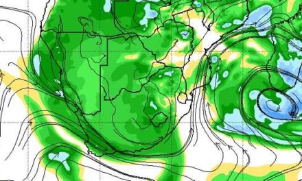
What’s coming?
By weekend an upper air trough forms to the west. This predictably remains until mid-week. Within the trough a cut-off vortex forms above the 850hPa level, extending above the 200hPa level, before weakening into a troug. It creates considerable convergence. The northwesterly input becomes more evident above the south, the prospect of light showers also looms from the coast at Walvis, eastward to the Botswana border off and on from Sunday; apart from a brief colder surface incursion, Monday, the northerly half remains within the warmer influence as air drawn toward the disturbed patterns evolves away to our south.
Cold is limited during this week but local early morning frost remain a risk