


Fortnightly overview and short-term outlook to Wednesday 05 June 2019
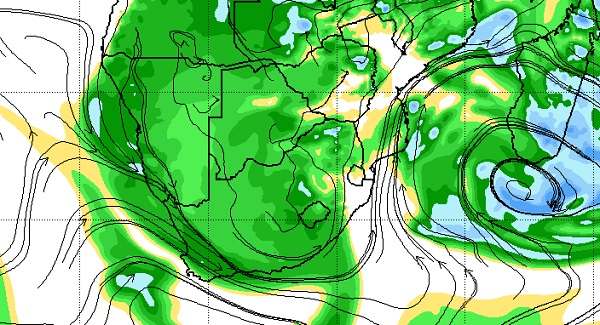
Visual: Relative humidity at 700 mB for southern Africa at 18:00 on Thursday 30 May.
Source: Climate Prediction Centre of the National Oceanic and Atmospheric Administration (NOAA) of the US Government.
www.cpc.ncep.noaa.gov/products/international/cpci/data/12/gdas_700mb_rh_safrica.html
Recent Developments
A similar local weather pattern has been repeated for the past two weeks, neatly demonstrated by this week’s visual.
As the South Atlantic high migrated from west to east around the southern tip of the continent, high pressure control was evident over much of the sub-continent’s eastern half. This lead to extensive ridging over South Africa, Zimbabwe and Botswana with a strong anti-cyclonic circulation on the surface and up to about 12,000 feet.
Once the high has shifted far enough to the east, a low pressure trough formed in the middle layers, between 10,000 and 20,000 feet, running from southern Angola across Namibia’s western half, into the Northern Cape. This could be seen from the ground as relatively good cloud formation visible at the 15,000 feet elevation, and again much higher up above 25,000 feet. The lower cloud system looked in most aspects like a summer development while the alto clouds presented a more typical winter pattern.
But as with last week, this week’s cloud development was also fast to appear, and then just as fast to dissipate, getting the hopes up of those waiting anxiously on the ground for signs of rain. Sadly though, whatever little precipitation there was, it could only be measured in half millimetres.
Early this week, a fairly strong cyclonic front crossed the Western Cape at the 500 mB level, roughly some 18,000 feet aloft. Although it was not matched by conditions on the surface, it produced atmospheric instability that reached as far north as Walvis Bay. This system was opposed by the airflow from the north following the trough from north to south, growing in intensity as the week progressed.
Where these two systems met, so-called undercutting took place and due to the instability in the mid-levels, it created positive conditions for convection which resulted in the observed cloud formation over a very large area of Namibia from Kunene in the north-west, through the interior to the eastern half of the Karasburg district.
The question then is: Where does the moisture come from? This is what the 700 mB relative humidity chart shows. The green areas in the visual depict areas of moderate humidity, on average between 50% and 60%. As can be seen, there is ample moisture present over Namibia but only in the middle layers. Compare for instance, the blue areas over Angola, Zambia, Mozambique and Madagascar where relative humidity is upwards of 80%.
For Namibia it means that there is sufficient humidity but restricted to a fairly shallow atmospheric layer. On the surface, conditions are controlled by the high pressure cells crossing the Cape as can be seen by the cold nights, and the predominantly south to south-westerly airflow.
At cloud level, the airflow follows the direction of the trough (north-west to south-east) which could also be seen in the direction of travel of the individual clouds.
But above these levels (30,000 feet and higher) at the end of the troposphere, the jet stream blow the entire system rapidly to the east. This is why the clouds appeared so suddenly and exited just as quickly.
Although the clash between southern and northern systems produced unseasonally good cloud formation, the prospects for rain were extremely limited, as experienced over the past two weeks.
On the Radar
The cloud-bearing system only has limited potential for the eastern strip of the Hardap and Karas regions along the South African border, and perhaps in the Orange River valley but by Saturday the system will have shifted away from Namibian territory.
For the rest of the weekend, the entire country will have clear skies, cold early mornings and warm to hot late afternoons. Conditions will also be very quiet with little surface wind since the atmosphere returns to a mostly stable stance.
Monday to Wednesday see a typical early winter pattern with high pressure control both on the surface and in the alto levels. A trough that starts to develop during Sunday night offshore the northern Namib coastline becomes more prominent on Monday. As the high moves over South Africa, there is extensive ridging from the east (Botswana) that reaches backwards across Namibia up to the escarpment.
This pressure differential causes a steady easterly airflow over the interior, descending down the western face of the escarpment and crossing the coastal plain to the ocean.
There is a good chance that the central and northern Namib will experience strong Oosweer on Monday and Tuesday, which should subside by Wednesday.
The winter’s first serious cold front appears on the radar during Wednesday night but it will be another two days before it has a local effect.


