Weather 19 August 2016
What Happened
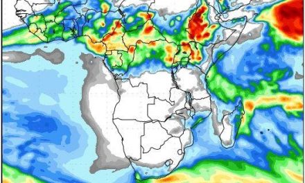
The week was dominated by a mid-level trough which brought some light precipitation to the Sperrgebiet, the Karasburg district and later into the eastern part of the Keetmanshoop district. These showers showed up in satellite images but have not been confirmed by terrestrial observation for the lack of weather stations and reliable weather monitoring in the farthest reaches of the vast underpopulated southern districts.
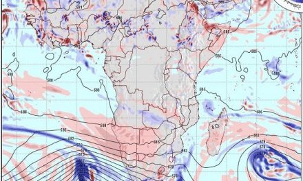
A contiguous high pressure system enveloped the entire southern Africa offshore from Oranjemund in the west to Maputo in the east. It displayed all the characteristics off late-winter high pressure dominance, ridging onto the South African interior during the second half of the week, and from there pushing back across Botswana up to the eastern section of Namibia.
Over Namibia, the mid-level trough lay west of the high pressure ridge. The extent and the persistence of the high kept the trough situated over the Namibian interior with windy conditions the whole week. The trough flows from north-west to south-east as is typical. Where it encounters the high (over the South African interior) it is blocked and forced to rise. This leads to convection, and subsequently precipitation. The tail-end of this system produced the cloudiness and the precipitation in the south-east. The obstruction of the trough by the high causes this system to develop “backward” almost like a damwall stopping the flow of a river. As the dam fills, it pushes the river level higher upstream. The same happens when a trough is obstructed by a high pressure system. Its front rises (over South Africa) but its tail fills up (over Namibia). This produces clouds and once there is sufficient convection, also light rain. How far the trough will back up then becomes a question of how long the high will remain in place.
The trough is marked by windy conditions since it is a low pressure system by definition. But the obstruction of the trough also has another effect. At its point of origination, in this case southern Angola, its airflow slows down. This lowers the theoretical cloudbase but it also brings in a “deeper” atmosphere witnessed by the height of the 500 mB isobar. This “thicker” atmosphere with retarded mobility leads to diabatic compression and the temperature on the surface rises. This was evident the entire week over the regions north and north-east of Etosha where very hot conditions reigned. Later in the week, it was also evident over the central interior where evenings were warmer than late afternoons.
What’s Coming
During the weekend, the enveloping high splits in two, presenting a more typical late-winter pattern with a high pressure cell south of Madagascar and the South Atlantic high just offshore Oranjemund.
With the obstruction out of the way, the trough develops in strength at the same time shifting to the east. This will bring windy conditions to the Botswana border and even some more light rain.
However, the South Atlantic high makes landfall during Sunday and conditions quickly change.
By Sunday afternoon, the wind should be howling in Lüderitz and the Karas region will cool down considerably with night temperature dropping to around 5°C. Ahead of the approaching high, a cold front moves over the Northern, Western and southern Cape provinces bringing cold conditions to the Karasburg district on Monday. As the system crosses South Africa, the airflow over the southern half of Namibia brings in the cold, first from the south, and then a day later (Tuesday), from the south-east.
By Monday, the high pressure cell covers most of the South African interior with the familiar “backward” ridge over Botswana and the south-eastern quadrant of Namibia.
This leads to another two very cold nights (Monday and Tuesday) over the Karasburg and Keetmans districts, and even up to the Omaheke Otjozondjupa border.
The pressure differential between east (high) and west (low over the coastal plain) causes very windy conditions over the escarpment from around Khorixas in the north right down to the confluence of the Konkiep and the Fish in the south.