


Weather 04 December 2015

What Happened?
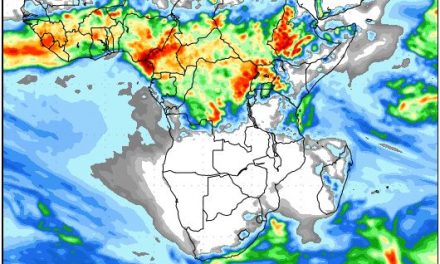
A well-defined mid-level trough developed over the weekend bringing windy conditions to the interior. By Monday, this trough has spread from southern Angola through the Namibian interior and into the Northern Cape Province. It advected extensive cloud cover into the central parts bringing widespread but scattered rains to large areas from Owamboland, across Etosha, across the central interior and up to the Botswana border as far south as Aminuis.
Until about a month ago, a late winter pattern still dominated the synoptic map. This has now changed as can be observed by the rapid approach and succession of multiple high pressure cells. These originate in the South Atlantic and follow their relentless path towards the African continent, where they are deflected by the continental heat, following a trajectory south of Cape Agulhas and then eastward to the Mozambican Channel where they usually have a strong influence that may reach as far north as Tanzania. Once they have crossed south of Madagascar, they become the Southern Indian high pressure cell, which is the main driver of moisture from the Indian Ocean, back towards the continent.
During winter, the progression slows down due to lower sea surface temperatures. It was a notable feature of this past winter that the South Atlantic high stayed stationary some 2000 km offshore, often for days or even a week. On the eastern side of the continent, the same phenomenon occurred with the Southern Indian high often staying in situ south east of Madagascar for a week or longer.
That pattern has now been replaced by a more typical summer pattern with enhanced mobility of the high pressure cells along the so-called high pressure belt, spanning the entire southern hemisphere.
This week’s synoptic progression provides a textbook example of summer activity. In the wake of the migrating high came the familiar intrusion of warmer, lighter, moister air from Angola. This trough moved across the country as the week progressed, increasing in intensity, manifesting a lower cloudbase, and shifting towards the east. Whereas by Monday it lay stretched across Namibia from north to south, by Friday, it was only present in the north-eastern quadrant bringing light precipitation to the Kavango and more substantial falls to the eastern Caprivi section of Zambezi.
While the airflow was predominantly from the north for the first half of the week, by Thursday it has veered around completely, coming from the south. By Friday it has backed to the east in the southern half of the country, while the north-easterly flow resumed from Friday.
The rapid succession of the high pressure cells can best be understood as an enormous pump covering the entire southern Africa, When the high approaches, its leading edge causes airflow from south to north, nighttime temperatures come down and dry conditions prevail. As the high migrates towards the east, its trailing edge ten takes over the massive pump action, but then the airflow is from the north, the temperatures rise, and cloud cover increases. This pattern will be repeated endlessly throughout the summer until early April next year.
What’s Coming
The after-effects of the passing high only has an impact up to this Friday. From Saturday onwards, the airflow backs to north-east, then northerly, and by Sunday evening, the northern half of Namibia is covered in cloud from the Kunene mouth, southwards across the interior to that area of the Kalahari where it straddles the Namibia Botswana border.
But the next high also approaches rapidly, forming a very prominent convergence line where the high on the surface (southern Namib) meets the (low pressure) trough in the mid-level (north eastern quadrant). From Sunday night trough Monday and Tuesday, more substantial rainfall can be expected than this past week for most of Namibia except for the southern Namib, the southern escarpment and the Karas Region
A very positive sign is that two leading forecasts expect the Inter-Tropical Convergence Zone, for the first time this season, to cross the Kunene River during Sunday night with its apex development during Tuesday and Wednesday. This should bring significant rainfall to the Kunene region from Tuesday onward.


