


The Week’s Weather up to Friday 13 October. Five-day outlook to Wednesday 18 October 2017

Bar Chart: ENSO Outlook as at 14 September 2017 showing highest probability for La Nina conditions from November 2017 to March 2018.
Source: ENSO update prepared by the Climate Prediction Centre in the National Oceanic and Atmospheric Administration of the US Government.
The second Ice Angel passed through the land this week and the third will be here on Monday. This piece of German folklore best illustrates that repetitive cold intrusions in October are not the exception and have been recorded for about 150 years.
Namibian weather is always determined by the interplay between the cold, high pressure cells originating over the South Atlantic, and the warm, low pressure systems from the tropics. These two meet over Namibia forming a so-called convergence zone where conditions on the surface are controlled by the South Atlantic high, and aloft by the reigning anti-cyclonic circulation prevalent over the sub-continent most of the time.
During the transitional period between winter and summer, the systemic interplay can be observed from cool to cold nights, and warm to hot afternoon conditions. In the early morning, the high pressure dominance is felt on the surface and usually witnessed by an extreme cloudbase elevation. As the day progresses, the sun’s heat weakens the high pressure, replacing the cold surface air with warm air from the north.
This week is a prime example of high / low interaction and how it brings unseasonally cold conditions to the southern half during the night and early morning.
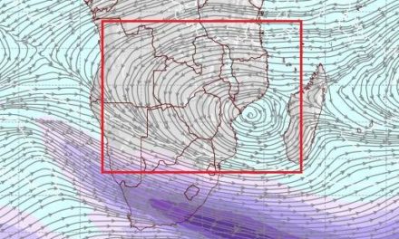
At the beginning of the week, the South Atlantic high was still offshore by a few hundred kilometres. It was of reasonable strength, measuring 1028 kB at its core and extended over about 3000 km of ocean. As it made landfall, it migrated across South Africa from west to east but the core remained offshore, slipping around Cape Agulhas around Tuesday and bringing cold conditions to the larger Cape area. By Wednesday, the cold reached southern and central Namibia where it lingered for three days.
The real synoptic action, however, was some 1500 km south of Madagascar where a marked depression developed turning into a proper vortex by Thursday. This low pressure system amplified the effect of the high pressure cell over land, indicated by the extremely low absolute humidity readings over central Botswana and Namibia. On Thursday morning, most Namibian weather stations except those at the coast, registered humidity readings below 10%. This is indeed very low and more typical of midwinter conditions. To the person on the ground, it brings a noticeable discomfort, and the UV levels are off the charts.
By the end of the week, the South Atlantic high sat immediately south of the continent, the low pressure system south of Madagascar was still active and strong, and tropical air was only present over the Kavango, Bwabwata and Zambezi.
What’s Coming
The weekend sees Namibian weather split along a clearly defined convergence zone running from Ruacana in the north-west across the interior to Ariamsvlei on the Namibia South Africa border in the south-east. West of this zone, the South Atlantic high remains dominant while in the east, hot to very hot conditions continue.
A cold front ahead of the South Atlantic high reaches the Namibian south and interior by Monday. It effectively splits the country into a southern half / northern half pattern. Conditions in the south will be cold on Monday getting warmer on Tuesday.
The north is under the impact of the so-called heat-low centred over northern Botswana. The presence of the heat low is the first portend of true summer but it needs to develop for another month.
The northern half will be hot and by Wednesday, the Kavango, Bwabwata and Zambezi will be blistering. No rainfall is expected but some cloudiness is indicated for the areas close to the Angola and Zambia borders.
The predictive chart at the top shows the probabilistic development for La Nina conditions in the equatorial Pacific. While a full-blown La Nina episode is not expected, current conditions indicate a short La Nina phase from November to March. This translates into positive expectations for the upcoming Namibian rainfall season.


