


Weather overview and short-term outlook to Wednesday 18 August 2021
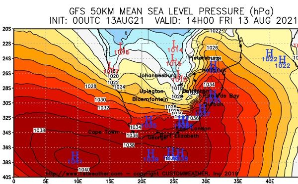
Visual: Synoptic map of southern Africa isobars on Friday afternoon, 13 August.
Source: Customweather.com. http://clients.customweather.com/1STWX/plots/AVN_mslp_small_day1.gif
Recent Developments
This week again gave a vivid display of the 1-, 2-, 3-day west, south, east winter dynamic as the Atlantic High Pressure cell approached, passed and departed the continent.
By Friday afternoon (when the visual applies) the high was about midway on its migration from west to east, giving it another two days in which to bring colder conditions to South Africa, Botswana and Namibia.
The high’s core is surprisingly strong, measuring around 1040 mB, a value confirmed by the synoptic charts of the South African Weather Service. The surprise lay in how quickly it intensified when its northern rim made landfall. Earlier in the week, around Tuesday the barometric pressure in the core was still only 1028 mB but this rapidly increased during Wednesday to 1036 mB and during Thursday night, it notched up another four millibars.
Note that the visual again shows that the core is over or close to the 40°S parallel. This is not entirely unusual for winter, especially when the cores are strong but it is a significant pointer to the coming summer when the cores stay on this track when they enter the Indian Ocean where the water is warmer.
This week’s cold intrusion is not out of the ordinary. It was a very typical occurrence for August and it will repeat again before we reach spring but it is unlikely that it will lead to frost, even in the south.
For a longer-term view of the season, we need to look to the Pacific Ocean where El Nino Southern Oscillation (ENSO) conditions are currently neutral, but against all models of earlier this year, are now expected to return to La Nina before the end of this year. If that is indeed the case, it will certainly produce some surprising events during the summer.
On the Radar
The weather is about as uneventful as a soccer match. The weekend will be cooler but not cold with temperatures in the south going as low as 5°C but reaching about 24°C in the afternoon.
For the central parts, the conditions will be similar but the temperatures about 5°C higher on average. In the northern parts, the first persistent afternoon readings above 30°C in some places wil happen in the next five days.
The next South Atlantic high pressure cell will arrive here next Wednesday night and the whole process will repeat for three to four days.


