


Weather overview and short-term outlook to Wednesday 09 June 2021
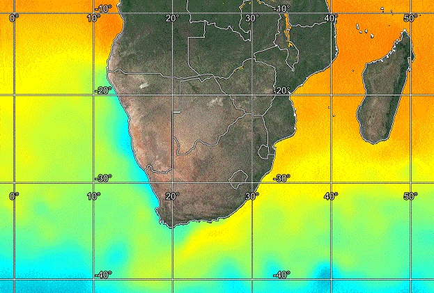
Visual: Sea Surface Temperatures for southern Africa
Source: Space Science and Engineering Center, University of Wisconsin-Madison, https://realearth.ssec.wisc.edu/
Recent Developments
Sea Surface Temperatures for southern Africa are as normal as can be for early winter. The visual shows warmer water off the east coast with the signature cold upwelling along the west coast. The only slight anomaly is the blend of cold and warm patches south of Cape Agulhas where the Benguela and Indian Ocean currents meet but this area is prone to shifting temperature patterns due to the difference in temperature, thus a difference in water density.
What we can see here is that there is really cold water at latitude 40° South, roughly 1000 kilometres south-west of Cape Town. This cold water is the host for the core of the South Atlantic high pressure cell, and it was that cell that penetrated the subcontinent’s interior on Tuesday with the first blast of icy air from the southern seas.
The interesting, somewhat anomalous feature of the week’s cold spell was that the cold front did not actually make landfall but skirted around the continent just south of Cape Agulhas. It was the leading edge of the South Atlantic high that advected the cold air from south of the continent across the western interior and into the Namibian and Botswana interiors. A further surprise was the intensity of the high’s core.
At 1032 mB, this was a fairly dense pocket of cold air, comparable to the 1036 mB readings we can expect later in June and early July. This core migrated across the southern half of South Africa, maintaining its 1032 mB reading indicating that the cold air was not just surface bound but carried on aloft for thousands of feet. The disturbances that we experienced on the ground were mirrored in 500 mB (18,000 feet) maps, and in some areas even higher. Were the system shallower, the core’s reading would have subsided fairly rapidly once it crossed land.
The result was widespread snowfall over the higher ground of South Africa and fairly cold conditions in Namibia, Botswana and Zimbabwe.
There is a strong correlation between the Sea Surface Temperatures and the high pressure systems that develop over the colder areas. This is also evident from the visual. Where the water temperature is indicated by a blue shade, is also the position and track of the South Atlantic high’s core.
Typical to a winter pattern, the cold first penetrated Namibia from the south-west as the South Atlantic high moved closer to shore. Then, as it approached land, it was deflected by the ever-present anti-cyclonic circulation, shifting southward but settling over South Africa’s higher ground once the leading rim reached the southern end of the Mozambican Channel.
This produced a very typical pattern for a cold intrusion in Namibia. From the south-west on Tuesday, then south-east on Wednesday then shifting to east on Thursday and finally to the stock-standard north-east on Friday.
On the Radar.
Unbelievable as it may sound, the north-easterly airflow continues during the weekend, gradually shifting to the north, bringing warmer conditions to the interior
By next week the next approaching South Atlantic high nears the coast, again with a strong offshore south to north airflow, very similar to this week. It moves into southern Namibia by Tuesday where it encounters the warmer airflow from the north, forming a weakly-defined convergence zone.
This area of interaction between the southern and northern systems is confined to Namibia’s western half but it has the potential to lead to precipitation during Tuesday night and Wednesday over the eastern half of the Karas Region. This precipitation may occur in the form of snow.


