Weather 12 December 2014
![]() What Happened
What Happened
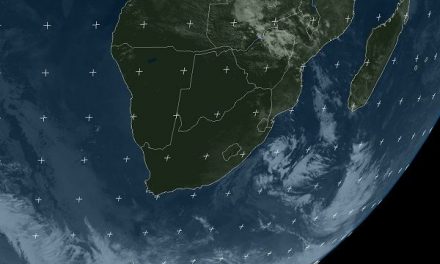
The somewhat dislocated position of the South Atlantic high pressure cell is still the main feature of the local synoptic map. For many weeks, the position of this cell was further north than usual. A broad swathe of warmer water, in places by as much as two degrees, stretches from the Cape of Good Hope to the northern section of the coast of Patagonia in Argentina. This band of warmer water may be the reason for the northerly displacement of the South Atlantic high but meteorologists are not in agreement over this.
The so-called heat-low over the southern African interior is the strongest inland feature. It is very prominent at surface level reaching up to the middle levels at some 30,000 feet. This heat-low opposes the South Atlantic high, especially on the surface and in the middle layers. Between the heat-low and the eastern fringe of the South Atlantic high, a rough convergence line forms daily leading to a prominent airflow from the south-east west of the convergence line, and a strong airflow across the country from the Kunene River to the Kalahari, east of the convergence line. This created a band of cloud over the northern, central, and south-eastern parts with isolated or scattered showers almost every day. In the upper air, a strong anti-cyclonic circulation controls conditions, acting as the engine that drives the daily inflow of moisture in the middle levels from Angola. However, the core of this circulation is situated over the Angola Zambia border and is still too far north by about 1000 km, to advect moisture across Namibia in all three levels – surface, middle and upper. Only when the anti-cyclonic core shifts to where the Sashi meets the Limpopo, will the main rain season start in earnest.
Rainfall for the past two weeks
04 Dec
Eunda Agricultural College 45.0, Okongo 42.9, King Nehale Gate 14.7, Eenhana 11.7, Ondangwa 9.0, Oshikango 4.6, Oshakati 2.8, Von Lindequist Gate 2.0, Okaukuejo 1.0, Mariental 1.0, Maltahöhe 0.8, Tsumeb 0.7, Oranjemund 0.2
07 Dec
Windhoek HQ 29.6, Steenboklaagte 16.0, Okahao 15.2, Katutura 14.1,Q Aroab 7.4, Aranos 5.9, Okongo 5.5, Eenhana 2.7, Otjiwarongo 2.6, Grootfontein 2.2, Sesfontein 1.6, Omaruru 1.2, Oranjemund 0.6, Oshakati 0.4, Bagani 0.3, Gobabis 0.2, Okaukuejo 0.2, Rundu 0.1, Outapi 0.1, Opuwo 0.1, Tsumeb 0.1
09 Dec
Oshikango 36.8, Eenhana 0.5, Otjiwarongo 0.2, Mpacha Airport 1.0, Omaruru 0.3, Oshakati 3.0, Grootfontein 4.0, Okahao 22.2, Okaukuejo 0.2, Tsumeb 0.1, Oranjemund 0.6, Bagani 0.2, Opuwo 0.1, Steenboklaage 27. (Source: Namibia Meteorological Services)
What’s Coming
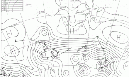
The synoptic stance remains relatively static for the weekend and into next week. The South Atlantic high maintains its position further north than usual and has a marked impact on coastal conditions. The winds will be fresh to strong, from the south-west at Oranjemund, but more south-easterly at Lüderitz. The presence of this high pressure cell relatively close offshore brings south-easterly winds over the southern Namib and the western sections of Karas and Hardap. It also controls conditions on the surface, again producing some unseasonally cool nights. This lasts until next Wednesday. The low pressure area over the interior of southern Africa stays more ore less in the same place with the western half of Botswana bearing the brunt of the heat. This obviously means that Namibia will be at its hottest during the day close to the Botswana border. A weakly-defined trough forms on a daily basis but shifts progressively to the east during Saturday and Sunday. For Monday and Tuesday, rain is expected only north and east of Otjiwarongo. Conditions in the Zambezi have changed considerably over the past week and forecasters now expect precipitation over the Caprivi for the whole weekend and next week.