


The Week’s Weather up to Friday 05 May Five-day outlook to Wednesday 10 May
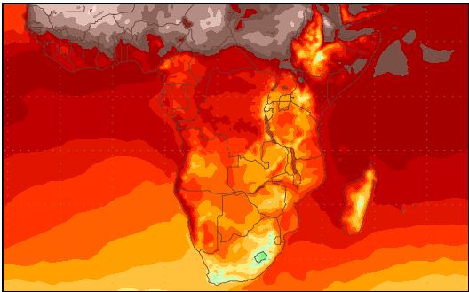

Temperature forecast from Friday 05 May to Saturday 13 May 2017
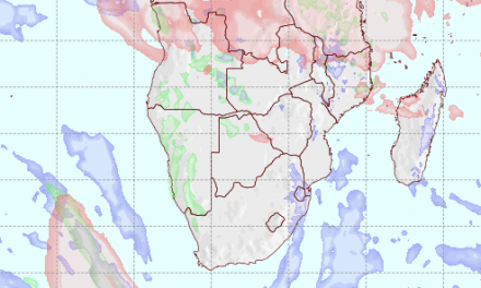
Precipitation forecast from Friday 12 May to Friday 19 May 2017
Source: wxmaps.org, GrADS/COLA
The two maps selected for this week’s discussion of local weather, cover two back to back weather windows.
The first map shows the maximum temperatures for the one-week period starting this Friday 05 May indicating that for most of this period, Oosweer in some form, will impact the coastal weather.
The second map is the expected rainfall, not for next week, but for the week after that from 12 to 19 May. It has been selected because it shows, that contrary to popular expectation, there may still be some life left in the rain season, and the forecasting model shows this.
This week was marked by the fairly rapid west to east migration of the South Altantic high pressure cell around the southern Cape towards the southern Indian Ocean. As the leading high departed, the space it vacated in the South Atlantic, it was quickly occupied by the next approaching South Atlantic high. Both high pressure cells were fairly strong, measuring between 1032 mB in the east and 1028 mB in the west. Between the two highs a low pressure area developed which grew in strength as the week progressed.
Over Namibia, the lower pressure was only present along the coastal plain but south of the Orange River, it formed a proper trough driven by the north to south airflow on the western fringe of the high pressure cell over South Africa.
This synoptic stance is typical of the intra-seasonal phase where there is neither a strong summer nor winter bias. The usual result is enhanced north to south airflow over Namibia, which is also the reason why moisture continued to penetrate Namibian airspace from the north.
However, this moisture was restricted to the surface level between the ground and about 12,000 feet aloft. Higher up, moisture rapidly fell off with very little remaining in the upper layers above 25,000 feet.
Another hallmark of the intra-seasonal period is the control of opposing weather systems at various levels of elevation. While surface conditions are still indicative of a summer pattern with the mentioned airflow from the north, higher up, the growing strength of the South Atlantic high exerts a noticeable control.
This could readily be seen during the week with daily cloud formation, even into the southern Namib, but with restricted convection. Put simply, the moisture was present at the levels around 12,000 feet but ridging in the upper air (high pressure control) prevented the clouds to grow the tops they need for proper convection. As a result, while ample cloud was visible over most of the interior east of the escarpment, they did not develop into proper Cumulus Nimbus type. Restricted vertical velocity means restricted convection, resulting in little or no rainfall.
By the end of the week, the synoptic map showed an almost wintery pattern with a high south of Madagascar, the South Atlantic high some 600 km west of Cape Town, and lower pressure over the western half of the sub-continent, i.e. Namibia. Airflow remained north to south.
What’s Coming
The overall weather pattern continues to show a bottom layer, upper layer split. On the surface, the airflow over Namibia is north-east to north, driven by the high pressure cell over South Africa. In the upper air however, the South Atlantic high exercises control with a strong zonal flow from west to east.
A well demarcated convergence zone, that started developing on Thursday, grows in strength but is moved along from west to east by the South Atlantic high. It crosses the Karas Region during Saturday and Sunday.
A typical intra-seasonal pattern remains in place during the weekend, extending into Monday and Tuesday. This means higher pressure over Botswana and lower pressure over the coastal plain, with partly cloudy days that do not produce any rainfall. Oosweer will reign, again the farther north one goes, the stronger.
It is only by Wednesday evening, that the first blast of cold air from the south is expected to reach the Karas Region.


