


Weather overview and short-term outlook to Wednesday 22 July 2020
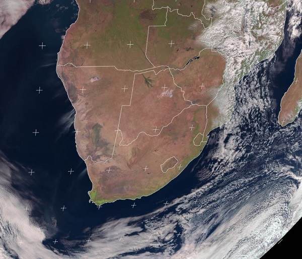
Visual: Daytime satellite image of southern Africa at noon on Friday 17 July.
Source: Eumetsat, https://eumetview.eumetsat.int/static-images/latestImages/EUMETSAT_MSG_RGBNatColourEnhncd_SouthernAfrica.jpg
Recent Developments
The power of the South Atlantic high pressure cell was vividly demonstrated when it penetrated Namibia from the south-west, then went northward across the country reaching even the highlands in central Angola.
This week’s cold intrusion is a so-called diabatic process. It means the energy (or lack of it) is contained in the system itself and not transported from an external origin. In layman’s terms it simply indicated that the high pressure cell was already very cold when it made landfall, it did not advect the cold from another source, usually polar air from the Antarctic.
As an aside, Oosweer is a typical adiabatic process. This denotes that the airflow in Oosweer, although zonal on the surface, is actually descending or sinking air as a result of topography – the difference in elevation between the central plateau and the coastal plain.
When the high pressure cell was still offshore during the previous weekend, it had a typical mid-winter barometric pressure of 1024 mB. It was only when it approached the continent that a very strong frontal system developed. This system brought copious rain to the Western Cape a week ago and was so strong, it spilled into southern Namibia where rainfall of anything between 15mm and 40mm was measured over a very large area from the coastline all the way across the Karas region to Ariamsvlei. This was indeed an unusual occurrence because the total winter rainfall in the south, in a normal year, usually adds up to only about 15mm for the entire season.
Behind this front, the high pressure cell quickly grew in intensity, reading 1032 mB by Tuesday but it was only as it drifted across the continent that its real strength showed. By Wednesday, the early morning pressure over much of South Africa read 1036 mB, which is exceptionally high even for winter. This moved into Namibia through Botswana leading to very cold mornings in the south-eastern quadrant and the eastern districts along the Gemsbok Park and the Botswana border.
These very high pressures over the interior of the sub-continent were in stark contrast to the lower pressure over the coastal plain, causing very windy conditions, especially at night when the pressure differential was most active. As can be expected, the wind was strongest at or near the escarpment where the pressure difference was the biggest. Evidence of the strong winds can be seen in this week’s visual with sandy plumes blowing off the Namibian coast into the Atlantic.
This cold intrusion was atypical in more than one sense. Not only was the core very cold, it penetrated far north into Botswana, Namibia, Angola, western Zambia, Zimbabwe and even the low lying Mozambique. In the visual, the front still shows in the east covering most of Mozambique, Malawi and northern Zambia.
On the Radar
As the high pressure cell shifted to the east, the wind veered from the south-east to the east, bringing in more cold across Botswana’s plains, but by Friday it had already resumed its northerly flow, with a marked improvement in temperatures as warmer air came in from the north.
The easterly airflow continues during the weekend which sets the stage for Oosweer at the coast. However the outlooks disagree over its intensity and location.
The most probable scenario is that Oosweer will be restricted to the area between Swakopmund and Hentiesbaai, gradually developing to the south during Sunday while pulling away in the northern Namib.
The wind over the interior should remain easterly to north-easterly and on the coastal plain mostly from the east, so the potential for Oosweer or Oosweer-like conditions are there. The unknown factor is how close will it come to the shoreline and whether it will fizzle out about 30 km before it reaches the sea.
For next week, a return to “normal” winter conditions is expected with no new cold intrusions.
Interestingly, a quick check in the Economist weather archive revealed that the last similar occurrence like this week was in 2008, giving some credence to the notion of the 11-year solar cycle and that this may have a lot to do with this year’s winter.


