


Weekly weather overview and short-term outlook to Wednesday 16 October 2019
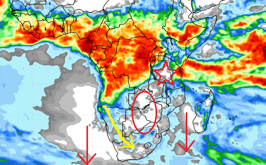
Visual: One-week rainfall forecast for sub-Sahara Africa
Source: GrADS/COLA, George Mason University
Impact of regional developments
The visual for this week comes from a very popular source of meteorological information. These colour maps are displayed on many websites, usually to convey messages of good expectations for good rains.
The reality, however, is not that simple, requiring a more in-depth look at what exactly the visual is telling us.
The outlook is for cumulative precipitation over eight days. This already tells something about the robustness of the underlying model, especially past day four. From experience we know that the South Atlantic high pressure cell can be quite mobile this time of the year, so forecast conditions can change rapidly when the high shifts, especially if this is accompanied by either a drop or a rise in the barometric pressure in its core. In practice it means that these maps are only reliable for two or three days after which it becomes intelligent guessing done by a computer based on the algorithms with which it is programmed.
The visual furthermore shows a number of assumptions, all of which are relevant to the actual outcome. The first to notice is the red pentagram. This white area shows that the forecasters believe the intermittent high pressure influence in central and western Tanzania will continue over the short to medium term. This is not thumb-suck but actually based on observed conditions. The red oval over the central part of the sub-continent is the precursor to the high pressure influence in Tanzania. The logical deduction is that as long as there is high pressure control in this area, it will continue to feed the high pressure control in Tanzania, and subsequently continue to block the moisture route from the Indian Ocean into central Africa.
The implication is that the atmosphere in East Africa will remain fragmented for still some time. This is also the reason why heavier than normal rainfall is expected along the East African coast. The so-called Indian Ocean Transport has become very active over the past two weeks but it is blocked inland in the western half of Tanzania. This leads to depleted vapour in central Africa and the spill-on effect is that there is less vapour in Angola and Western Zambia, thus also less to be advected into Namibia. This blockage of the inland destination of the Indian Ocean Transport is the first impediment to good rain in Namibia.
The second assumption is based on the position and relative strength of the South Atlantic high. In the visual it is mirrored by the large open white area offshore Namibia and South Africa. The high’s core has often meandered northward during this year, repelling the anti-cyclonic circulation over the sub-continent’s interior and causing drought in Namibia. In fact, both the South Atlantic and the southern Indian highs’ cores are still displaced to the north by anything between 800 and 1000 km.
The third assumption is that the mid-level trough, indicated by the fat yellow arrow, will become more active and grow in strength. This is a signature element of Namibia’s weather during summer so it is only natural that any scientist will expect it to become active at some stage. According to the visual, that is in the next week.
This visual was chosen to show that one must approach weather forecasts with circumspection. Although we had a blessed week with a strong system in the South along the Orange River and the first CB formations for the season in the North, overall rainfall prospects will not improve before the high pressure influence in Tanzania has receded and the two high pressure cells either side of the continent have started to migrate southward as indicated by the two red arrows.
On the Radar
The general weather stance has moved visibly into an early summer patter. This is witnessed by the southern boundary of the Inter-Tropical Convergence Zone running just north of Madagascar with a deep southerly intrusion in Angola.
Typical late-afternoon thunder storms are expected over the weekend for the northern half of the country but the statistical probability is low (less than 40%). The bias is firmly in the west.
By Monday the mid-level trough becomes more active bringing moisture to the central interior and even perhaps as far south as Mariental. In the northern half the bias still remains in the west.
From Wednesday onward for the rest of next week, the brief positive conditions are on hold with only a slight chance for rain in the north-west (Kaokoveld) and south-east (Karasburg District).


