


Weekly weather overview and short-term outlook to Wednesday 18 September 2019
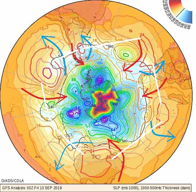
Visual: Surface level synoptic map of the southern hemisphere on Friday 13 September
Source: GrAds / COLA, George Mason University, http://www.wxmaps.org/fcst.php
Recent Developments
The visual for this week shows the location of the cores of the high pressure cells as they are distributed along the high pressure belt of the southern hemisphere. It is a most revealing visual as it shows only four major cells and a lesser, still budding cell off the Patagonian coast.
A month ago, the southern hemisphere synoptic maps showed six, sometimes seven cells in the same space now occupied by four. The implication is that the distances between cores have grown considerably over the past month. The further implication is that whereas the high pressure cells only moved at a sedate pace during winter, they have now accelerated which is also the reason why the cores are moving apart. The distances between cores are indicated by the white lines.
High pressure cells, although very dense and slow at their cores, drive tremendous atmospheric “pumps” for lack of a better word. Ahead of every high pressure cell is an enormous pump that advects cold air from the south to the north. The mechanism is the same regardless of the high’s position around the hemisphere. These northward-working pumps are indicated by the blue arrows.
Trailing every high pressure cell, is another powerful pump but this time from north to south. These pumps take lighter, warmer air from the tropics to the Antarctic zone. These pumps are indicated by red arrows.
When the cores are bundled too closely together, as has happened during this winter, the only cold that reaches Namibia is the air from the high pressure cell itself. The blue pump route is obstructed by the interlinking highs meaning that Namibia got cold because the air in the cell is cold, but it did not get the intense below-zero cold air from the Antarctic. This is the reason why the winter was so mild with only two semi-cold intrusions.
This has now changed significantly and is one of the best observations of how conditions have shifted from very negative for precipitation above the continental escarpment, to reasonably positive for the upcoming season.
If the blue pumps are not active, then also the red pumps do not work, and they are the mechanisms that drive airflow from the warmer north, in our case from Angola, Zambia and the DRC.
Overall weather conditions have now started changing perceptibly. As the number of sunshine hours increases every day, the pumps should grow stronger, at least for a while until that point when so-called heat-low conditions set in over the southern African interior.
A strong but restricted cold front moved across the South on Tuesday bringing cold, wet, overcast conditions to the Karas region up to about Grünau with many reports of light drizzle from Rosh Pinah, Ai Ais, Grünau and the south-western corner of the Karasburg district. The fact that a winter system that originated off the west coast managed to penetrate so far north, is indicative of just how the strength of the blue pumps has come back.
On the Radar.
The feature to watch is the intense low pressure vortex, huddled west of the kidney-shaped South Atlantic high pressure cell. In the visual it shows as a smallish green circle. It should reach the continent in about a day or two, and in the South its impact will be felt during Saturday.
By Sunday it will have moved to just east of the southern Cape and some nighttime cooling may be experienced in Namibia’s south east along the Gemsbok Park border and possibly further north along the Botswana border. It will be very brief and for the whole next week, temperatures in the central and northern areas are expected to reach or go above 30°C.
It must be pointed out that the leading outlooks do not agree regarding the impact of the approaching vortex, with one outlook favouring a cold penetration deep into the Namibian interior.
All agree however that the intrusion will be very brief and that the predominant airflow over the entire country will veer to north-easterly and then northerly within a day afterwards.
With increased sunshine hours per day, and strong advection from the north, there is a good chance that next week will bring some widespread cloud formation in both the middle and upper levels of the atmosphere.


