


The Week’s Weather up to Friday 18 August. Five-day outlook to Wednesday 23 August 2017
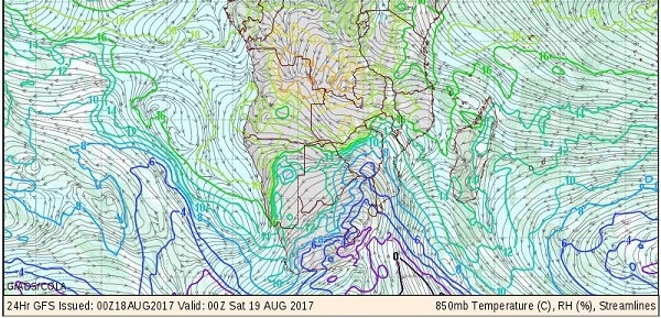
Diagnostic Map: Observed conditions for southern Africa on Friday, 18 August 2017. This map shows the midnight temperature at the 850 mB level, about 1000 feet above the surface of the interior plateau, as well as relative humidity and the direction of airflow. Source: GrADS/COLA.
On 28 July 2012, the afternoon temperature in Windhoek reached 27°C. Less than two weeks later on 11 August 2012, the nighttime temperature went down to -2°C.
It seems that the current season has many similarities to conditions in 2012. The way local weather progressed during the week is certainly indicative of a late winter surge. Following in the wake of this week’s cold intrusion is another cold spell which should reach Namibia next week Tuesday or Wednesday. The barometric pressure map for the whole southern hemisphere, at this point shows another strong cold front about ten days from now.
This winter has been exceptionally mild. Temperature anomaly maps consistently showed higher than usual temperatures for the entire Namibia with very high daytime temperatures for the northern and north-western areas, extending down the coastal plain into the southern Namib.
That changed dramatically during Wednesday night when fresh winds started blowing over Namibia’s interior. Wind direction was south-east indicating the source of the cold was the high situated over South Africa south of the Orange River latitude.
In the first half of this winter, the high pressure cells around the hemisphere were spread anomalously far apart. This allowed much opportunity for north-south-north airflows meaning that cold fronts were neatralised by the strong north to south winds just ahead of the frontal systems. Thus, although there were ample cold fronts, they tended to pass south of the continent, not making landfall, and decrease in strength as they migrated from west to east.
Those conditions have changed markedly a fortnight ago and as a result, Namibia had its first serious cold intrusion this week.
In a typical mid-winter fashion, early in the week the regional synoptic map showed an offshore South Atlantic high pressure cell, a southern Indian high south of Madagascar and a continental high over South Africa.
The South Atlantic high made landfall on Tuesday night, spreading across South Africa during Wednesday and Thursday. The southern Indian high remained more or less in place south of Madagascar but a significant low pressure system developed in the Mozambican Channel, spreading southward during the week.
The presence of lower pressure in the Mozambican Channel is what enabled the South Atlantic high to extend much further north than on any previous occurance this season.
The map best explains why it took two days from the time that the high made landfall in the Western Cape, for the full effect of the cold intrusion to reach Namibia.
Airflow on the leading (eastern) rim of the South Atlantic high is from south to north. This mechanism advects cold antarctic air towards the continent. This northward advance will typically be blocked by the anti-cyclonic circulation over southern Africa but this time the low pressure system in the Mozambican Channel acted like a massive suction pump, actually drawing the frontal system towards it. The result was a northward penetration much further than expected.
What’s Coming
The cold conditions do not stay long and by Saturday temperatures normalise although it will still be cold during the night in the Karasburg and Keetmanshoop districts, and by Sunday morning further northwards along the border with Botswana.
Late winter conditions continue throughout the weekend and into Monday. By Monday night the next frontal system makes landfall in the Western Cape and the Karas Region should feel it fairly quickly. The same mechanism as this week is at work so the rest of Namibia will only start experiencing some of the cold as from Tuesday night.
Again similar to this past week, the colder air will reach the central interior by Wednesday but then coming from the east.
While the eastern half is engulfed by higher pressure and consequently lower temperatures, a low pressure system gradually develops along the coastal plain spreading towards the south from the Kunene River mouth. The pressure differential is substantial enough for sand storms to develop over the central Namib particularly in the Walvis Bay district on Wednesday.


