


Overview for the week and 5-day outlook to Wednesday 10 October 2018
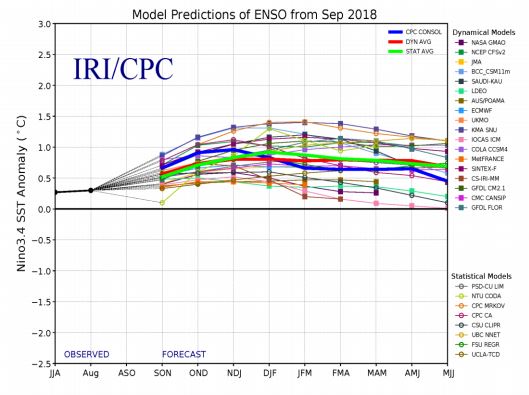
Visual: Late September Spaghetti plume of the El Nino Southern Oscillation outlook up to the end of July 2019.
Source: International Research Institute (IRI) for Climate and Society in the US Government’s National Oceanic and Atmospheric Administration.
www.cpc.ncep.noaa.gov/products/analysis_monitoring/lanina/enso_evolution
What Happened
El Nino conditions in the equatorial Pacific are now confirmed by four different indicators.
1. Sea Surface Temperatures (SSTs) are now higher by some 1° Celsius over large areas with small, more localised patches showing an anomaly of as much as 1.5° C.
2. Sub-surface water temperatures at depths from about 100 to 300 metres are higher by as much as 3° C.
3. There are strong westerly wind anomalies over the West Pacific acting as an obstruction for the normal east (cooler) to west (warmer) sea surface current. Consequently, SSTs in the East Pacific has risen by more than a degree in just two weeks.
4. The 30-day Southern Oscillation Index compiled by the Australian Bureau of Meteorology has fallen to about -10 points, well below the -7 value which is regarded as the lower limit for neutral conditions.
A warmer Pacific Ocean is also corroborated by the spaghetti model which serves as the visual for this week’s discussion. It is important to note that all three solid lines in green, blue and red, remain mostly above 0.5° C indicating a consensus expectation that El Nino will be with us until the middle of next year.
Overall, current equatorial Pacific conditions can no longer be regarded as neutral. There has been a marked shift to El Nino conditions in just a fortnight. Although it will take five more months before the scientists are prepared to declare officially an El Nino event, the shift of the past two weeks has taken current conditions well into El Nino territory.
The local effect has also become visible. Whereas Namibian weather was still “normal” a month ago albeit slightly delayed, there is a perceptible bias for lower pressures over the country’s western half. Although this is fairly common during summer, other weather elements are not in full-blown summer mode yet, showing clear late-winter or at least, a transitional stance.
The most interesting feature of this week is the well-developed vortex south-west of Madagascar. This cyclonic circulation is drawing moisture at the lower levels away from the eastern half of the sub-continent but is putting it back high up in the alto levels from where it returns to southern Africa following the short route through Mozambique, Zimbabwe and Zambia. From there it collects in southern Angola before entering Namibian airspace from the north.
This mechanism is also delayed as isolated upper atmosphere moisture is a regular occurrence for September. This usually manifests as substantial clouds at levels above 30,000 feet from which long sheets of rain are produced but nothing reaches the ground. The elevation is simply too high. It is called virga, the Latin for Old Man’s Beard since the appearance of the rain bursts reminds one of a longish, scruffy beard.
Although the Inter-Tropical Convergence Zone is notoriously difficult to pin point so early in the Austral summer, there are signs that it is active in the west where the southern boundary now lies more or less on the Angola DRC border. In the east it is difficult to place indicating a fragmented atmosphere over East Africa and consequently, an obstruction to the Indian Ocean transport which advects moisture into central Africa.
What’s Coming
Two prominent features in local weather will have an impact over the weekend. First, there is a fairly active trough present at around 18,000 feet running from southern Angola straight through Namibian airspace into the Northern Cape. Second, a well-developed cut-off low sits about 500 kilometres offshore Lüderitz on Saturday, moving closer to the coastline during Sunday.
The combination of these two systems will bring much unstable air to the southern Namib and there may be some wet surprises on the coastal plain but also further inland in the vicinity of the escarpment. This system migrates eastward by Sunday afternoon and by Monday will be present over the pre-Namib in both the Hardap and the Karas regions.
The mid-level trough over the interior also shifts towards the east but slowly and may bring light rain (if anything more than virga) to Omaheke, eastern Otjozondjupa and the southern areas of the Kavango.
By Wednesday another vortex develops south of Madagascar leading to a repeat of this week’s synoptic progression. East Africa will be devoid of moisture while it will return at very high levels to Angola and from there enter the Namibian interior. It is doubtful whether much of the moisture in this system will reach the ground.


