


Overview for the week and 5-day outlook to Wednesday 19 September 2018
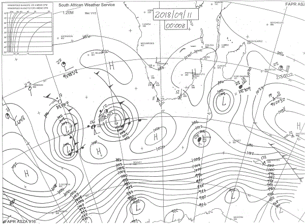
Visual: Synoptic map of southern Africa for midnight Monday/Tuesday, 10,11 Sep.
Source: South African Weather Service, www.weathersa.co.za/observations/synoptic-charts
What Happened
The visual for this week is a deviation from the usual forward-looking approach by weather watchers. Since nothing is as obsolete as yesterday’s weather, there must be a good reason to choose a synoptic map from the beginning of the week.
Tuesday’s synoptic map, while not extraordinarily complex, is still usefull as it marks a clear turning point in the seasons, from a more typical winter stance, to a fairly static early summer stance on Friday. This rapid transition is characteristic of Namibia’s weather, usually surprising most people how quickly it shifts from late winter to summer.
This week, most of Namibia excepting the coastal plain, has moved into a discernible summer pattern. At the beginning of the week the South Atlantic high pressure cell broke into two cores as it approached the continent. The northern core, offshore the Kunene River mouth, had a 1020 mB reading while the southern core, located about 800 km south of Cape Town, had a standard winter reading of 1024 mB. The southern Indian high with its core some 1500 km south-east of Madagscar, had an impressive (almost mid-winter) reading of 1032 mB.
At the end of the week, however, both cores have moderated considerably. The southern Indian high receded to a normal 1024 mB while the mighty South Atlantic high all but collapses, at least that part close to the continent. The continental high had departed and a weak cold fronted drifted slowly past Cape Agulhas.
The result could be felt across Namibia with daytime temperatures for the first time this season going above 30°C for most of the country except for the coastal towns. The high pressure control during the day was minimal and the daily increasing number of sunshine hours coupled with the sun’s higher angle, steadily increased terrestrial energy.
The only wintery vestige that remained was the north-westerly airflow over the northern Namib with unseasonally dense fog in the early mornings. This was mirrored by relatively cool nights which served as a reminder that high summer conditions have not yet manifested.
This intra-seasonal phase of the local weather makes forecasting very difficult. Whereas relative humidity at surface level was uncommonly high during the winter, it has dipped to below 10% this week causing hayfever symptoms in many people. This very dry air was however restricted to the surface and mid-level atmosphere. For instance, on Tuesday, a very long vapour trail was spotted for the first time, indicating that relative humidity above 30,000 feet must be higher than 60%.

On the northern horizon, things started moving with a well-developed low pressure area covering a about one third of north-western Angola. This may be indicative of the Inter-Tropical Convergence Zone shifting southward, but it is a little to early in the season to make that call. Noteworthy is that most of the southern DRC and Western Zambia was still devoid of cloud, corroborating the very low humidity levels in Namibia.
What’s Coming
The same quiet, hot conditions of Thursday and Friday continue during the weekend. There is a budding cut-off low some 500 km south-west of Oranjemund but it will only start having an effect during Sunday night, if at all.
As from Monday, two opposing systems start making an impact. From the south-west, the outer rim of the South Atlantic high will have a cooling effect up to about Walvis Bay and across the southern Namib.
From the north, the first intrusion of unstable air starts from the Kunene River mouth and then gradually spreads to the south-east. The convective activity will be limited to altitudes above 15,000 feet, so although come cloudiness is expected along the entire Angolan border with very hot days in the north, convection will be limited and no rainfall is expected.
These two strongly opposing systems meet along a convergence zone running from Walvis Bay skew across the country to Mata Mata. Nothing is expected to develop in this zone due to the very low humidity levels, while the high’s cooling impact is forecast to remain restricted to south of the Orange River.


