The Week’s Weather 23 December 2016
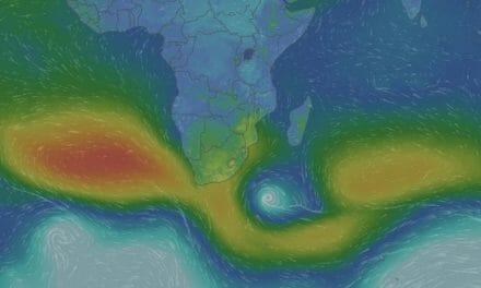
The most noticeable weather development over the past week is the strengthening of the Inter-Tropical Convergence Zone over East Africa. Up to a fortnight ago, this zone was well defined and visible only over West Africa with infrequent incursions into central Africa and Angola where its southern boundary sometimes came within 400 km of the Namibia Angola border. Still, its bias was more to the north of the equator with limited activity in Africa south of the equator.
Compared to the South American continent where the ITCZ in the southern hemisphere has been very prominent and visible since the end of the winter, the African part was fragmented and irregular. Over East Africa, it was mostly absent leading to a fragmented, relatively shallow atmosphere restricted to an altitude of about 45,000 feet. Under normal conditions, this time of the year, the East African atmosphere should reach vertically to a height of at least 56,000 feet. This atmospheric fragmentation over East Africa obstructs the zonal flow in the mid and upper levels from the Indian Ocean into central Africa. When moisture over central Africa is restricted, eventually the southern part of Africa experiences reduced rainfall, relative to the point in the season. This was most evident in Namibia where, according to the 3-month outlooks published in September, the quarter October, November, December had a 60% to 80% chance of above-normal rainfall. This did not turn out to be so.
Rainfall in Namibia is by nature erratic so any probabilistic model must be used with circumspection. On the coastal plain, for instance, very small amounts of moisture can lead to very large distortions in the overall rainfall probabilities and actualities. This is because the statistical base is so low. In an area that typically gets only 50mm a year, 100mm constitutes a 100% anomaly, although it is still hyper-arid.
This week, for the first time this season, the Inter-Tropical convergence zone over East Africa became visible. Furthermore, it migrated relatively far south, deep into the Mozambican Channel and across the northern quarter of Madagascar. This is an indication that the atmospheric conveyors from the Indian Ocean to central Africa, are on the mend. This is a good sign especially for us in Namibia going into the main rainfall season after the equinox on 21/22 December.
The sub-continent’s two most important high pressure systems were more or less on track, although the core of the South Atlantic high pressure cell is displaced to the north by almost 1000 km. It is on the Walvis Bay latitude whereas it should be much further south, on the Saldanha Bay latitude in South Africa.
The southern Indian high pressure cell was in its customary position, 1000 km south-east of Madagascar, and of moderate strength with a core reading of some 1020 mB. Between the two highs, the typical summer low pressure system persisted over the sub-continent, leading to some advection of moisture from Angola into Namibia. Despite a relatively high cloud base, around 13,000 feet it produced cloud on a daily basis with light scattered showers from the Angolan border, through the interior and into Botswana.
A weak mid-level trough was in place over Owambo, the Kavangoes and Babwatwa. This produced enhanced advection with higher rainfall, spread more evenly, over these areas.
What’s Coming
The season has not reached its summer tipping point yet. From the discussion above, it is clear what the impediments are, but it also shows that conditions are turning positive. This should improve further in the quarter after the equinox.
The South Atlantic high continues to dominate surface conditions while the low pressure system from the north controls cloud formation at altitudes between 12,000 and 45,000 feet. A convergence zone is present from Terrace Bay, diagonally across the country to Noordoewer. Rainfall is possible almost every day, but it is equally impossible to predict where and how much. Only the central and southern Namib will remain clear and very hot.
Next update on 06 January 2017.