17 October 2014
![]() What Happened?
What Happened?
The layered atmospheric sandwich that started developing last week continued up to Wednesday this week at which point the last vestiges exited our airspace and crossed to Botswana and Zimbabwe. Although the stark difference in barometric pressure between Oranjemund and Katima Mulilo has subsided somewhat, the general situation of a high pressure push from the south-west, and a neutralising low pressure area in the north, remained in place. But this observation, again applies only to the surface, and up to about 7000 feet above sea level. These opposing two systems, one cold, one hot, create a phenomenon which is unique to Namibia and to this time of the year, a co-called inversion layer. The colder, denser air that pushes in from the south, forms the northern rim of the South Atlantic high pressure cell as it makes landfall, collapses, and circles the continent around Cape Agulhas. This is a surface system induced by the colder Atlantic waters, and it continues to hug the surface as it spreads northwards. From the north, on a daily basis as solar radiation increases, comes a broad column of lighter, warmer air, pushed southwards by the anti-cyclonic circulation which has its core over southern Angola. As the season morphs from winter to summer, it starts advecting limited moisture into the Namibian airspace, from the north. But because the air from the north is lighter and less dense, the cold air approaching on the surface from the south, displaces the warmer column of air, and it rises vertically. This is very typical of conditions in September and October.
It is also easy to observe from ground level. The thin layer of clouds are at the middle level, usually above 17,000 to 18,000 feet, but it is very limited in vertical extent, perhaps only a few thousand feet. The ceiling usually lies somewhere between 25,000 and 30,000 feet. Because of the anti-cyclonic circulation further north, it follows a signatory track from south-western Angola across Namibia into the northern provinces of South Africa. It is not a trough in the true sense but it displays some characteristics of a trough in the sense that it is a conveyor of moisture albeit a very limited one. Depending on local conditions, it may lead to some precipitation but because the layer of moisture is so shallow and the cloud base so high, we only get a few millimetres of rain. However, as this system migrates to the east, it builds in strength and once it reaches the Indian Ocean, it may lead to substantial rainfall as happened this week on Thursday and Friday off the coast of Kwazulu Natal. The inversion layer was present on Monday, Tuesday and Wednesday. The South Atlantic high followed its customary pattern bringing colder air, first from the south-west, then directly from the south, and by Thursday and Friday, it has swung around, bringing its colder air from the south-east and later from the east. Over Namibia it creates a yin-yan pattern as it progresses – lower pressure in Kunene slowly circling to the south along the coast, and higher pressure over the Kalahari slowly circling to the north up to Omaheke. Rainfall: Rundu 3.0; Rehoboth 15.7; Grootfontein 1.2; Okaukuejo 0.2 Oshakati 0.2 .
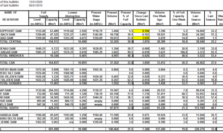
Source: Namibia Meteorological Service.
What’s Coming?
The Karas and Hardap regions will experience cooler nights over the weekend, with the cold moving towards the Botswana border in the east. The northern half of the interior remains hot to very hot.
A broad area of low pressure develops across the entire length of the northern borders but the anti-cyclonic circulation remains above southern Angola. This hot air enters Namibian airspace between Ruacana and the Kunene mouth from where it fans out to the south and the central interior.
Another inversion layer develops over the interior by Monday afternoon, but its effects remain limited to the Caprivi where light showers may be experienced on Tuesday and Wednesday. Similar to this week, it departs our airspace, moves to Zimbabwe, and eventually rains in Mozambique.
The wind follow a pattern similar to the face of a watch. At Lüderitz it will be south-west to south, at Noordoewer it will be south, over the Kalahari it will be east, over the Kavango it will be north-east, over Owambo, north, and over Kunene, north-west. At the central coast, it will be directly west.